Vatnajökull National Park, established in 2008, encompasses all of the Vatnajökull glacier and extensive surrounding areas. These include the national park at Skaftafell in the south-east and Jökulsárgljúfur in the north. Today Vatnajökull National Park covers 14% of Iceland and ranks as Europe's second-largest. In general, national parks are protected areas considered unique due to nature or cultural heritage. The unique qualities of Vatnajökull National Park are primarily its great variety of landscape features created by the combined forces of rivers, glacial ice, and volcanic and geothermal activity.
Vatnajökull is Europe's largest glacier, with a surface area of around 8,100 km2. Generally measuring 400-600 m in thickness and at the most 950 m, the glacial ice conceals several mountains, valleys, and plateaus. It even hides some active central volcanoes, of which Bárðarbunga is the largest and Grímsvötn the most active. While the icecap rises at its highest to over 2,000 m above sea level, the glacier base reaches its lowest point 300 m below sea level. Nowhere in Iceland, except for the Mýrdalsjökull glacier, does more precipitation fall or more water drain to the sea than on the south side of Vatnajökull. So much water is currently stored in Vatnajökull that the Icelandic river with the greatest flow, Ölfusá, would need over 200 years to carry this quantity of water to the sea.
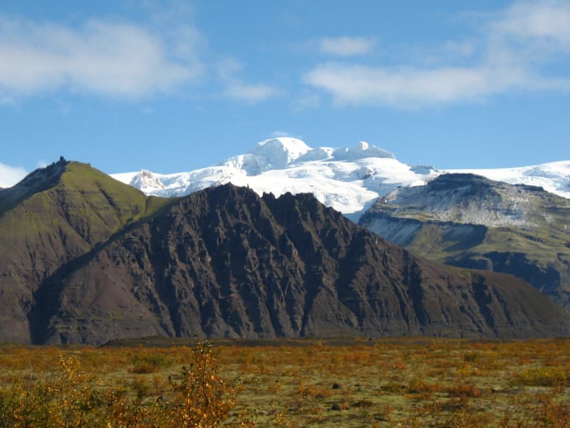
The south side of Vatnajökull is characterized by many high, majestic mountain ridges, with outlet glaciers descending between them onto the lowlands. The southernmost part of the glacier envelops the central volcano Öræfajökull and Iceland's highest peak, Hvannadalshnúkur. Sheltered by the high ice, the vegetated oasis of Skaftafell overlooks the black sands deposited to its west by the river Skeiðará. These sands are mainly composed of ash which stems from the frequent eruptions at Grímsvötn and is brought to the coast by jökulhlaups, or glacial floods. Substantial volcanic activity also characterizes the landscape west of Vatnajökull, where two of the world's most significant fissure and lava eruptions of historical times occurred, at Eldgjá in 934 and Lakagígar 1783-1784. Vonarskarð, northwest of the glacier, is a colorful high-temperature area and a watershed between North and South Iceland.
The objectives of designating Vatnajökull as a preservation area, along with the main regions it affects, are the following:
- To protect the nature of the region, including the landscape, biota, and geological formations, as well as cultural features
- To allow the public to get to know and enjoy regional nature, culture, and history
- To provide education on nature and nature conservation and regional history, society, and cultural features and encourage research to gain greater knowledge of these aspects.
- To strengthen communities and business activity in the vicinity of the park.
Visitor centers and other tourist information offices working with the park provide information and services for the park and its immediate environs.
The following offices operate along the south coast of Iceland:
Skálafell farm | Suðursveit | varying hours - all year
Hoffell farm | Nes | irregular hours - all year
*Opening hours for Christmas and New Year celebrations can be found on the website http://www.vjp.is
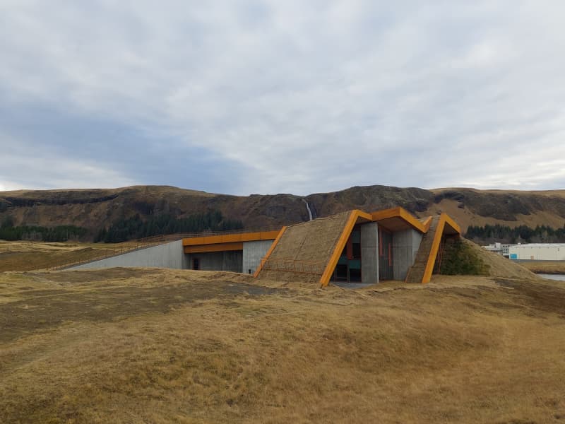
Skaftárstofa Visitor Centre, Kirkjubæjarklaustur
Skaftárstofa is the Vatnajökull National Park visitors center, located near Kirkjubæjarklaustur at Sönghóll by road number 1. It also serves as an information center for the municipality of Skaftárhreppur, and visitors have the option to see the exhibition "Springtrip" by the Iceland Glaciology Society. The exhibition, which was made on the occasion of the society's 70th anniversary, sheds light on its history, explains the construction of the society's cabins, trips on the glacier, glacial tongue measurements, research projects that have been carried out during spring trips to Vatnajökull, the glacier bacteria and the magazine Jökull.
Documentary Films:Eruption in Grímsvötn 2011Western part of Vatnajökull National Park
Opening hours
Participant in VAKINN Iceland tourism's official quality assurance organization
View
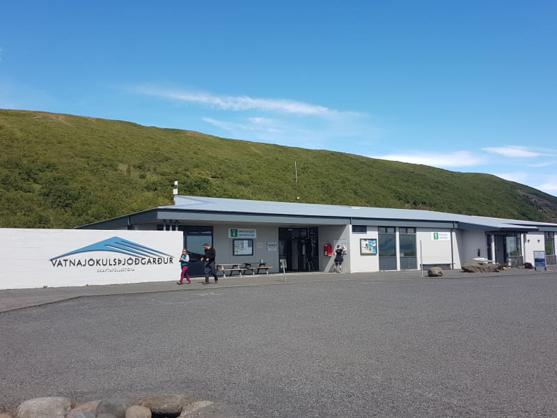
Skaftafell Visitor Centre, Skaftafell
Skaftafellsstofa is an information and education centre where visitors can find answers to their questions about the Skaftafell area, along with information about hiking trails, accommodation and nearby recreational options. The centre has an exhibition room with a film about the soutside of Vatnajökull National Park.
At the campsite there is WC, (also for the disabled), running water (hot & cold), shower, gift shop, cafeteria, coach service, service station, walking paths, hiking guide, outdoor grills, and washing machine. Exhibition showing the geology of the National Park. Service station close by and various other opportunities. For information ask at the service desk. The camping ground is open all year round
Participant in VAKINN Iceland tourism's official quality assurance organization
View
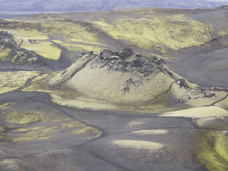
Lakagígar and Laki
Lakagígar is a row of craters formed in one of the world's largest mixed eruptions in recorded history. This continuous series of eruptions emitted a vast quantity of lava and substantial amounts of volcanic ash from a fissure stretching 25 km across the area west of the ice cap. The craters are regarded as a globally unique phenomenon and are, as such, protected within Vatnajökull National Park.
In 1783, a huge lava flow streamed from Lakagígar in what became known as the "Skaftá Fires." This is believed to have been one of the greatest lava flows in a single eruption in the history of the world: the molten lava filled the gorges through which the Skaftá and Hverfisfljót rivers flowed and swept down in two branches into inhabited areas, to spread over the lowlands where it laid waste many farms. The eruption produced large quantities of volcanic ash. For residents of the region and Iceland as a whole, the results of the eruption were catastrophic: this time is known as "Móðuharðindin" (the Haze Famine).
All roads in the western part of the national park are mountain tracks, only navigable for vehicles with four-wheel-drive; some only for large jeeps. Some sections of the road are rocky and full of potholes, and loose gravel is common. It is sometimes necessary to ford (drive through) streams and rivers which can become suddenly swollen, making them difficult, or even impossible, to cross. It is dependent on the weather when the roads are opened. Usually, they are open from early June through to autumn. Driving is only allowed on the roads marked on the accompanying map. All other roads or tracks are closed to the public. Here, as elsewhere in Iceland, driving off-road is banned by law.
View
Eldgjá canyon
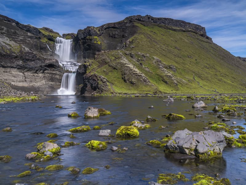
Eldgjá is an old tectonic graben reactivated in a massive eruption in 934-940. The Eldgjá vents form a discontinuous 75 km long volcanic fissure extending from the Katla volcano in the west to Vatnajökull in the east. The eruption in 934-940 takes its name from a spectacular 150 m deep and 8 km long chasm called Eldgjá (fire fissure) that occupies the central part of the vent system. Part of the fissure is under the protection of the Vatnajökull National Park. There you can take a walk along the bottom of the fissure and witness the sheer scale of it. An easy hike takes you from the car park (with WC facilities) along the bottom of the fissure to Ófærufoss waterfall. Getting there: you need a 4x4, and the area is only accessible in the summer. Eldgjá is a site of international geological significance. Ófærufoss is a distinctive two-tiered waterfall cascading into the fissure Eldgjá.
Eldgjá is reached by the mountain road Fjallabaksleið nyrðri (F 208), west of Kirkjubæjarklaustur. All roads in the western part of the national park are mountain tracks, only navigable for vehicles with four-wheel-drive; some only for large jeeps. Some sections of the road are rocky and full of potholes, and loose gravel is common. It is sometimes necessary to ford (drive-through) streams and rivers, which can suddenly become swollen, making them difficult or even impossible to cross. It is dependent on the weather when the roads are opened. Usually, they are open from early June through to autumn. Driving is only allowed on the roads marked on the accompanying map. All other roads or tracks are closed to the public. Here, as elsewhere in Iceland, driving off-road is banned by law.
View
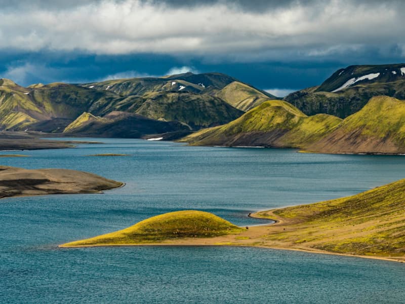
Langisjór Lake, Fögrufjöll, Grænifjallgarður
Langisjór is a lake within Vatnajökull National Park that's 20 km long and 2 km wide in some places. The lake is to the southwest of Vatnajökull, between the mountains Tungnárfjöll and Fögrufjöll, in a beautiful and picturesque landscape. Its square measure is 27 km², it reaches a depth of 75 m, and the water surface is 670 m above s
Langisjór is reached by the mountain road Fjallabaksleið nyrðri (F 208), west of Kirkjubæjarklaustur. All roads in the western part of the national park are mountain tracks, only navigable for vehicles with four-wheel-drive; some only for large jeeps. Some sections of the road are rocky and full of potholes, and loose gravel is common. It is sometimes necessary to ford (drive through) streams and rivers, which can suddenly become swollen, making them difficult or even impossible to cross. It is dependent on the weather when the roads are open. Usually, they are open from early June through to the autumn. Driving is only allowed on the roads marked on the accompanying map. All other roads or tracks are closed to the public. Here, as elsewhere in Iceland, driving off-road is banned by law.
View
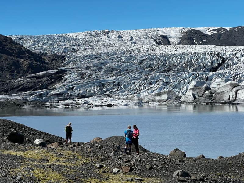
Skaftafell
Scenic nature, favorable weather conditions, and a network of hiking trails make Skaftafell in Vatnajökull National Park an ideal destination to enjoy outdoor activities in Icelandic nature. Short and easy trails lead to the waterfall Svartifoss and Skaftafellsjökull glacier. Still, those who want to reach further out Morsárdalur valley and Kristínartindar mountain peaks are perfect in terms of distance and labor. Skaftafell is also the ideal base camp for those who seek to climb Iceland‘s highest mountain peak, Hvannadalshnúkur.
During the summer months, the national park offers interpretive tours with rangers. Ask for information at the desk or check the park´s website.
Private travel companies operate in Skaftafell and offer guided hikes on the nearby glaciers and mountains. Also on offer are sightseeing flights over the Vatnajökull glacier and other renowned attractions.
Vatnajökulsþjóðgarður
View

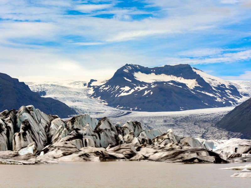
Jökulsárlón glacial lagoon
Jökulsárlón is a glacial lagoon beside the Ring Road, within Vatnajökull National Park. It is fed by Breiðamerkurjökull, an outlet glacier of Vatnajökull, and is known for the icebergs that drift across the lagoon before floating towards the Atlantic Ocean.
The area is one of the most popular stops in South Iceland, with views of blue-tinted ice, the glacier edge, and the nearby black sand beach where ice is often washed ashore. Seals can sometimes be seen in the lagoon or resting on the ice, but sightings vary by season and conditions.
Jökulsárlón is accessible year-round from Road 1, and there is a café by the lagoon. Visitors can also follow a marked hiking trail between Jökulsárlón and Fjallsárlón. Never step onto floating ice in the lagoon, as it can roll over or break apart without warning.
Vatnajökulsþjóðgarður
View
Skálafell – Hjallanes
Skálafell–Hjallanes is a hiking area between Jökulsárlón Glacier Lagoon and Höfn in Hornafjörður, within Vatnajökull National Park. The area gives visitors access to marked walking paths and glacier views in a quieter part of southeast Iceland.
One of the main routes is an 8 km circular hike through the Hjallanes area, leading towards the edge of Vatnajökull glacier. A walking bridge over the river Kolgríma also connects Skálafell with the Heinaberg hiking area, opening up more routes for visitors who want to explore the glacial landscape on foot.
Skálafell is close to Road 1 and can be a good stop for travellers driving between Jökulsárlón and Höfn. Check trail and weather conditions before setting out, and allow around 3–4 hours for the circular hike.
More trail information: Vatnajökull National Park
View
Heinaberg
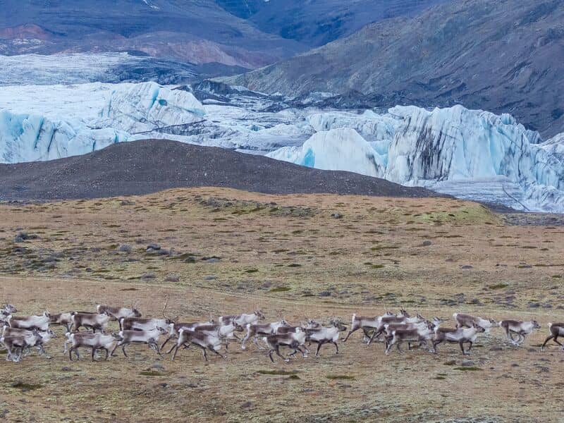
Heinaberg is a beautiful area that consists of Heinabergsjökull glacier, the glacial lagoon Heinabergslón, where you can go kayaking among the icebergs during summer, and stunning landscape. The Heinaberg area is part of Vatnajökull National Park.
The gorgeous glacial lagoon of Heinaberg, Heinabergslón, is accessible by car and is often studded with large chunks of glacier that break off the Heinabergsjökull glacier. The area offers excellent conditions for hikers, as it has several interesting hiking trails, along which one can see waterfalls, ravines, volcanic intrusions, and even, on a lucky day, a reindeer.
The gravel road from road no 1 to the glacial lake is not in service during the winter months. Therefore, one needs to be aware of changes in road conditions and accessibility.
Vatnajökulsþjóðgarður
View
Hoffell
Hoffell is a farmland and glacier area about 20 km from Höfn in southeast Iceland, and partially within Vatnajökull national park. The area is known for Hoffellsjökull, an outlet glacier of Vatnajökull, as well as gabbro rock, geothermal water, rivers, outwash plains, and mountain views.
Visitors can explore several hiking routes around Hoffellsjökull and Geitafellsbjörg, with views of the glacier and its lagoon. From Road 1, a 3 km paved road leads to Hoffell Guesthouse and Hoffell geothermal Baths.
To reach the Hoffellsjökull car park, visitors continue along a 4 km gravel road. The road is rough and can be difficult for ordinary cars, so a four-wheel-drive vehicle is recommended. Overnight stays are not allowed at the Hoffellsjökull car park, and hikers should check trail, road, and weather conditions before setting out.
View