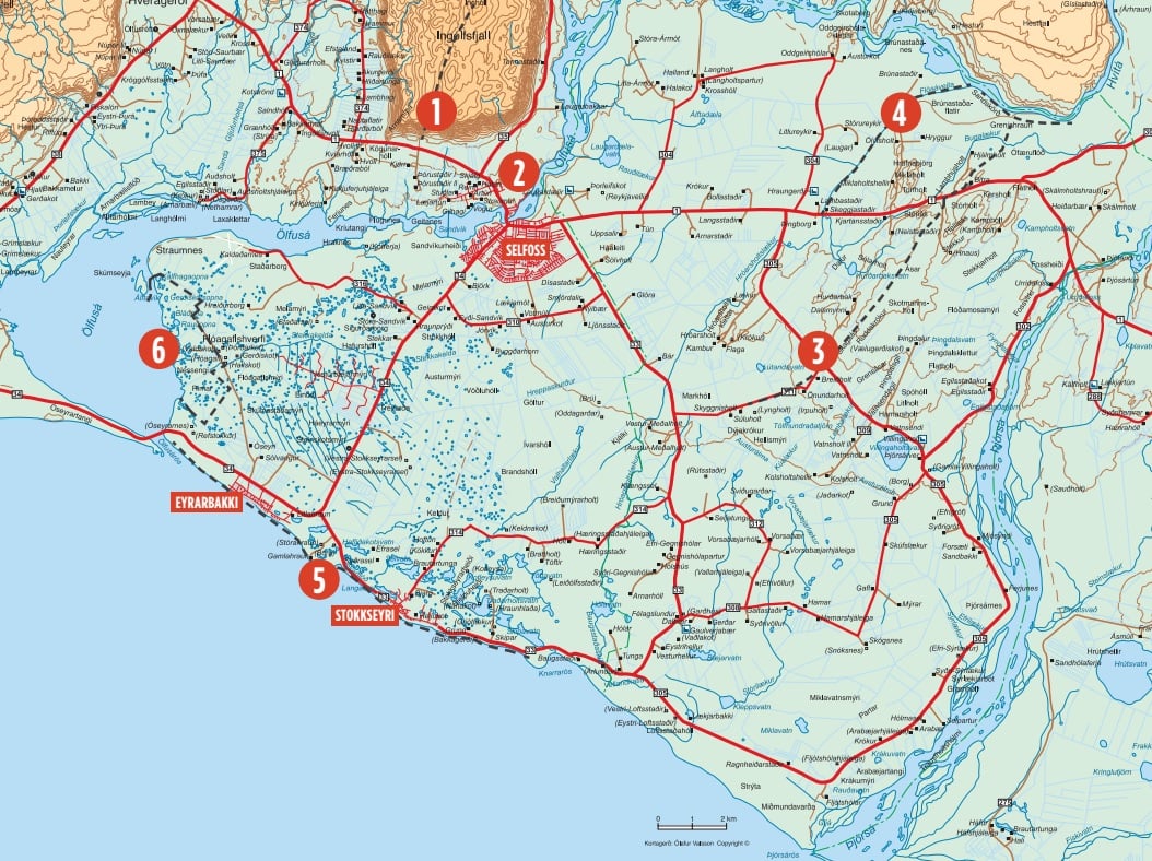
There are several various walking and hiking trails in Árborg and Flói. The list below provides information about a few of these marked trails. All of them have excellent views of the area, both mountain and ocean views. In this region are many birds and domestic animals such as horses, sheep, and cows.
- INGÓLSFJALL MOUNTAIN. The hike up Ingólfsfjall is at the mountains, south side by Djúpidalur valley; the valley is next to the gravel mine seen from route 1. The trail is on the east side of the mine. The hike takes about 4-5 hours, and the elevation is about 500m. The mountain is a bit steep, but some parts of the slope are easier to walk along the way. The length of this route is about 14-16 km. Once up, there is an excellent view of the region, the mountains, and the south coast.
Difficulty: Moderate - HELLISSKÓGUR WOODLAND. There are a few walking trails in Helliskógur, a woodland of about 126 hectares. All the trails are on flat land, and it won't take more than 1-2 hours to walk, so this area is very suitable for the whole family. In the forest, there is a cave called Einholtshellir, also known as the "big cave" by the locals. This cave has a lot of history, and you can read about it on page 45.
Difficulty: Easy - ÁSAVEGUR TRAIL. The Ásavegur road is a historical trail ideal for well-equipped hikers. The trail goes through a water protection area, and this is the ancient main route from Eyrarbakki village through the countryside to the north and east. The walking trail is about 14,5 km long and takes about 4,5 hours to walk, or you can shorten it and walk about 6 km. On rainy days the rail can be muddy.
Difficulty: Easy - THE IRRIGATION AT FLÓI. Head east on route 1 when you exit the town Selfoss. Shortly you will see Ölvisholt road (nr.303 on the left), on which you keep going until you see the main canal of the irrigation to the right. There you will find a sign with information about irrigation. Towards the east of the irrigation is a marked trail. The walking distance one way is about 4,4 km.
Difficulty: Easy - SOUTH COAST TREKKING. Down by the seaside, south of the town Selfoss is a trail leading between the villages Stokkseyri and Eyrarbakki. The trail is flat, straight, and about 4 km along the seashore. The surrounding landscape is very nice, and the lava coast Is rich with wildlife like birds and seals. The walk is suitable for the whole family.
Difficulty: Easy - FLÓI BIRD RESERVE. In reserve is a nice walking trail. From road 34, close to the village Eyrarbakki, you turn north on a gravel road and go to a farm called Stakkholt, where you can park. You will see a bird-watching shed in the wetland from the parking lot. In the bird reserve area is a walking trail about 2-2,5 km long, depending on the water level of the wetland. This walk is ideal for the whole family but be careful; your feet could get wet.
Difficulty: Easy.
Here you can find a map of walking trails in Árborg and Flóahreppur on pdf.

