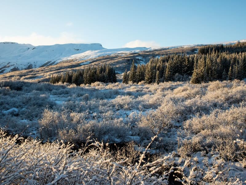
Forests, ponds, and family-friendly trails for relaxed outdoor time. Pack a snack, use facilities where provided, and leave each place as you found it.
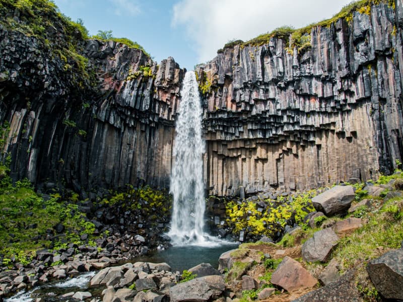
Svartifoss waterfall
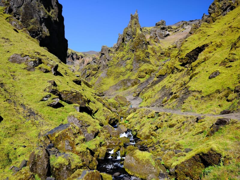
Svartifoss is one of the unique waterfalls in South Iceland. It is situated in Skaftafell, which belongs to Vatnajökull National Park. Svartifoss is 20 meters (80ft) high. It is bordered on both sides by tall black basalt columns.
The hike to Svartifoss starts at the Visitor Centre in Skaftafell. You can also find all sorts of information and advice about the area. The hike is about 1.9 km or 45 minutes (one way).
Skaftafell Visitor Centre, Skaftafell
View
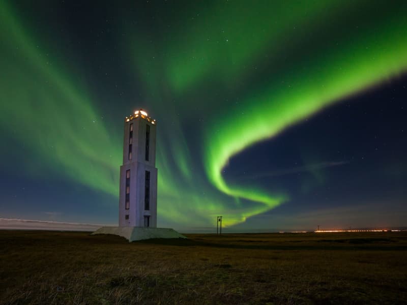
Knarrarósviti Lighthouse
Built-in 1938-1939, the lighthouse was the first one in Iceland to be built out of reinforced concrete. For a long time, the lighthouse was the tallest building in South Iceland, 26,2 meters (86 feet) high. It was designed by the engineer Axel Sveinsson as a blend of functionalism and art nouveau (jugendstil). In summertime (mid of June to start August) the lighthouse is open every day.
Knarrarósviti lighthouse is part of the beautiful South Coast Lighthouse trail that you can find more information about here.
View
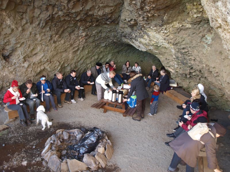
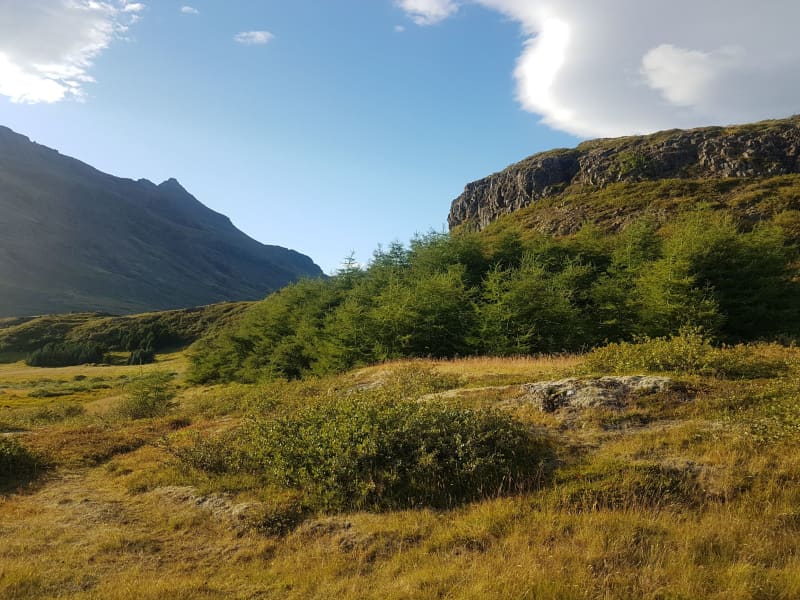
Hellisskógur forest
Hellisskógur is a small forest just outside of the town of Selfoss. In Hellisskógur are roads, walking paths around the area, and benches so visitors can relax and enjoy the site.
The cave in Hellisskógur forest was formed during a latter glacial period by sea erosion. Sea levels have been higher than now several times, and signs of sea erosion can be seen on more cliffs in the area, made of around 0, 7 – 3, 1 million-year-old basalt. The cave was previously used to store hay in the back and as a sheepcote in the front.
It was once believed that the cave was haunted by a ghost wearing a blue scarf. The story tells of a young man who was broken hearted and hung himself in the cave using a long blue scarf.
Here is a map of Hellisskógur
View
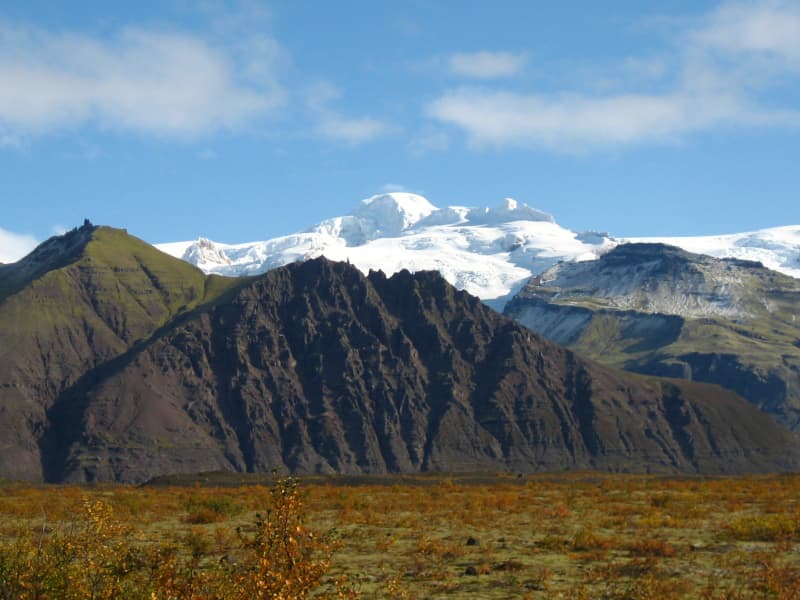
Hoffell
Hoffell is a farmland and glacier area about 20 km from Höfn in southeast Iceland, and partially within Vatnajökull national park. The area is known for Hoffellsjökull, an outlet glacier of Vatnajökull, as well as gabbro rock, geothermal water, rivers, outwash plains, and mountain views.
Visitors can explore several hiking routes around Hoffellsjökull and Geitafellsbjörg, with views of the glacier and its lagoon. From Road 1, a 3 km paved road leads to Hoffell Guesthouse and Hoffell geothermal Baths.
To reach the Hoffellsjökull car park, visitors continue along a 4 km gravel road. The road is rough and can be difficult for ordinary cars, so a four-wheel-drive vehicle is recommended. Overnight stays are not allowed at the Hoffellsjökull car park, and hikers should check trail, road, and weather conditions before setting out.
View
Einbúi, Oddgeirshólar
A beautiful sports and outdoor recreational area on the banks of Hvítá River. The area is owned by the Youth Association Baldur.
View
Höfðabrekkuheiði, Þakgil
A breathtaking 14 km drive from ring road no. 1 to Þakgil campsite and hiking area. Surrounded by black sand and glacial rivers, a gravel road crosses the heath of Höfðabrekka, a tuff ridge between rivers Múlakvísl and Kerlingadalsá formed during the last Ice Age when volcanic material forced its way from beneath the glacier following a sub-glacial eruption. The road is closed during the winter. The vegetation in this area is highly vulnerable to trampling; please always keep to trails.
View

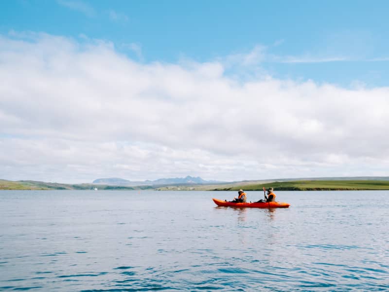
Úlfljótsvatn
Úlfljótsvatn is a family campsite run by the Icelandic Scout Association that has served as their home since 1941. At Úlfljótsvatn, campers can camp by the side of a beautiful lake and venture into some activities like Climbing, Kayaking, Archery, or Hiking.
Úlfljótsvatn sits in a privileged position just a few minute’s driving from Þingvallavatn. This means you can enjoy Icelandic gems like Þingvellir, Geysir, and Gullfoss within an hour of driving. Kérið, the volcanic crater lake, is also situated 15 min drive from our location.
Great first stop on the south coast, nature at its best, and Icelandic wonders on very easy reach.
View
Þórsmörk
Þórsmörk (Thórsmörk) is a natural gem that sits between Mýrdalsjökull to the east, the river Krossá in the south, with Markárfljót and Þröngá Rivers to the north. Its diverse landscape is characterized by impressive gorges, ravines, scrubby slopes, and a wide variety of unique vegetation. In times past, the farmers of Fljótshlíð and the area under Eyjafjall pastured their sheep all year round due to the mild climate found within þórsmörk.
Since the 1918 eruption of Katla, Þórsmörk was designated as a Natural Mountain Reserve. There are many curious natural rock formations in the area, such as Snorraríki, Sóttarhellar Cave, Álfakirkja (The Church of the Elves), Stakkholtsgjá Gorge, and the stone arch in Stóra Enda. Only large jeeps and buses can navigate the road into Þórsmörk due to the ever-changing volume of water, which can turn small and easily passable tributaries into tumultuous rivers in a matter of hours.
View
Haukadalsskógur Forest
Haukadalsskógur is a lush and expansive forest in Haukadalur valley, just a short drive from the famous Geysir geothermal area. Known for its tranquil atmosphere and diverse plant life, the forest offers a unique contrast to the dramatic geothermal landscapes nearby, making it a perfect stop for those seeking peace and natural beauty.
One of the largest national forests in South Iceland, Haukadalsskógur is also the most extensively planted of all Iceland’s national forests. It stands as a remarkable example of long-term reforestation, with planting efforts dating back to the early 20th century. Today, the forest features a rich mix of native birch and imported conifer species, creating a varied and shaded environment ideal for walking, picnicking, and nature observation.
The forest's outdoor facilities are well-developed and thoughtfully maintained. Among its standout features is a specially designed wheelchair-accessible trail, created in close cooperation with Sjálfsbjörg, the local association for people with disabilities in Iceland. This makes Haukadalsskógur an inclusive destination where everyone can enjoy the beauty of the outdoors.
View
Þjórsárdalsskógur Forest
The natural setting of the forest follows a varied landscape of intense contrasts, from flowering forests to unripe ash hake from Hekla. The forest is mostly birch and spruce, pine, and larch mixed forests. An ideal place for outdoor activities, as there are many marked and unmarked paths and forest roads in the woods.
Þjórsárdalsskógur lies west of Highway 32, where it goes east towards Búrfellsvirkjun. You can get into the forest from Ásólfsstaðir and also via a bridge over Sanda, a short way into the valley. The campsite in Þjórsárdalur is in between and is well marked.
In Þjórsárdalur, the forest stretches far up the slopes, the landscape is beautiful and varied, and it has a true fairytale atmosphere. There are numerous marked and unmarked paths and trails in the forest for travelers and hikers, rivers to swim in, and lava to explore. In the area, there are paths for wheelchairs, good camping, and a swimming pool in Árnes, about 15 kilometers down in the countryside.
Source: skoraekt.is
View
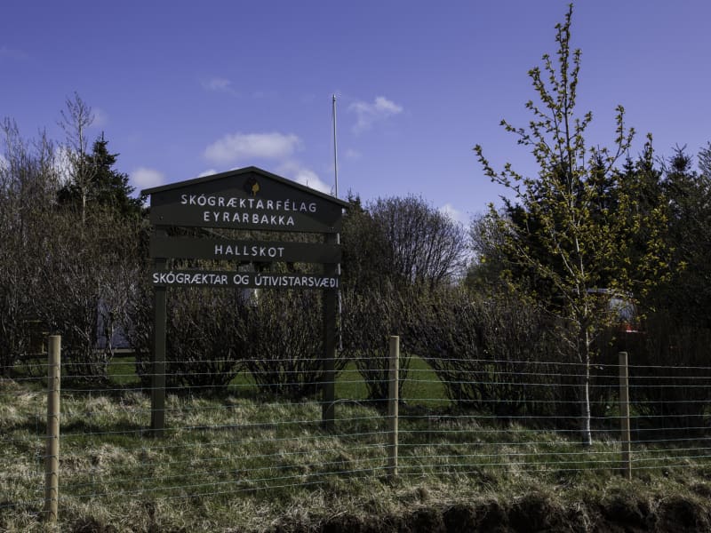
Hallskot - Recreation Forest
A recreation area north of Eyrarbakki in supervision of the forestry community of Eyrarbakki, Skógræktarfélag Eyrarbakka. In Hallskot is a perfect picnic area with benches and tables where one can always find a windless spot in the groves.
ADDRESS: 820 EYRARBAKKI / TEL: (+354) 660 6130, (+354) 847 5028 SKOGRAEKTARFELAGEYRARBAKKA@GMAIL.COM / GPS: 63°53'57.0"N 21°10'19.1"W
View
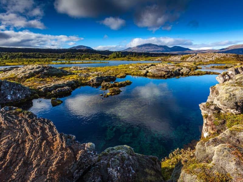
Þingvallavatn Lake
Lake Þingvallavatn lies in a rift valley that extends south from the Langjokull glacier to mount Hengill and from Botnssulur mountains in the west to Lyngdalsheidi heath in the east. The lake is the largest natural lake in Iceland, about 84 square kilometers, at an altitude of approximately 100 meters above sea level. The deepest part of the lake measures 114 meters, which means it reaches below sea level. The catchment area of Lake Thingvallavatn, about 1300 square kilometers, lies in the same direction as the fissure in the area, and its existence is closely connected with its geological history. The water in the lake is very cold and therefore very pure, so snorkeling and diving are popular. Silfra, one of the fissures in the northern part of the lake, is one of the most popular diving spots in Iceland.
View
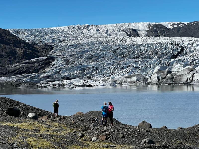
Skálafell – Hjallanes
Skálafell–Hjallanes is a hiking area between Jökulsárlón Glacier Lagoon and Höfn in Hornafjörður, within Vatnajökull National Park. The area gives visitors access to marked walking paths and glacier views in a quieter part of southeast Iceland.
One of the main routes is an 8 km circular hike through the Hjallanes area, leading towards the edge of Vatnajökull glacier. A walking bridge over the river Kolgríma also connects Skálafell with the Heinaberg hiking area, opening up more routes for visitors who want to explore the glacial landscape on foot.
Skálafell is close to Road 1 and can be a good stop for travellers driving between Jökulsárlón and Höfn. Check trail and weather conditions before setting out, and allow around 3–4 hours for the circular hike.
More trail information: Vatnajökull National Park
View
Haukafell
Haukafell is a forestry and outdoor recreation area east of Fláajökull glacier in southeast Iceland. The forestry project began in 1985 and now provides shelter for low-growing vegetation, including berry bushes that are usually ripe in August.
The area is used by locals and visitors for hiking and nature enjoyment. Several trails lead through the sheltered landscape, and a marked hiking route connects Haukafell with Fláajökull, crossing the Kolgrafardalsá river on a footbridge.
Haukafell is close to Road 1 and has a campsite in a scenic setting. Visitors planning to hike towards Fláajökull should check the weather and trail conditions before setting out, as conditions can change quickly near glacier areas.
View
Skaftafell
Scenic nature, favorable weather conditions, and a network of hiking trails make Skaftafell in Vatnajökull National Park an ideal destination to enjoy outdoor activities in Icelandic nature. Short and easy trails lead to the waterfall Svartifoss and Skaftafellsjökull glacier. Still, those who want to reach further out Morsárdalur valley and Kristínartindar mountain peaks are perfect in terms of distance and labor. Skaftafell is also the ideal base camp for those who seek to climb Iceland‘s highest mountain peak, Hvannadalshnúkur.
During the summer months, the national park offers interpretive tours with rangers. Ask for information at the desk or check the park´s website.
Private travel companies operate in Skaftafell and offer guided hikes on the nearby glaciers and mountains. Also on offer are sightseeing flights over the Vatnajökull glacier and other renowned attractions.
Vatnajökulsþjóðgarður
View
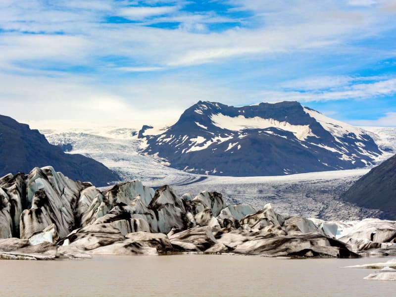
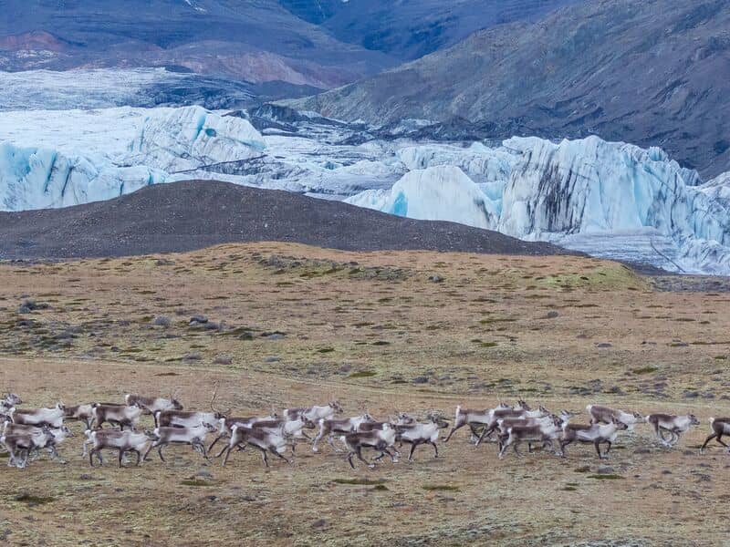
Heinaberg
Heinaberg is a beautiful area that consists of Heinabergsjökull glacier, the glacial lagoon Heinabergslón, where you can go kayaking among the icebergs during summer, and stunning landscape. The Heinaberg area is part of Vatnajökull National Park.
The gorgeous glacial lagoon of Heinaberg, Heinabergslón, is accessible by car and is often studded with large chunks of glacier that break off the Heinabergsjökull glacier. The area offers excellent conditions for hikers, as it has several interesting hiking trails, along which one can see waterfalls, ravines, volcanic intrusions, and even, on a lucky day, a reindeer.
The gravel road from road no 1 to the glacial lake is not in service during the winter months. Therefore, one needs to be aware of changes in road conditions and accessibility.
Vatnajökulsþjóðgarður
View
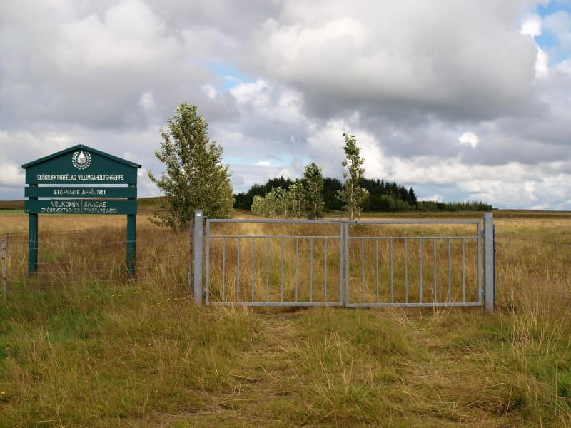
Skagaás grove
Skagaás grove is a small forest area in Flóahreppur, surrounded by young woodland and open countryside. The area has walking paths through birch, spruce, and pine trees, making it suitable for a short walk, a picnic, or a quiet stop while traveling in the area.
The grove is open to visitors and is easily accessible. Please help keep the area clean by taking all litter with you. Barbecuing is only allowed in the designated area because of fire risk.
View
Landmannalaugar - Nature Reserve
Landmannalaugar derives its name from a hot pool that rises under the Laugahraun lava field. Landmannalaugar has been a stopping point for people for centuries, and the mountain shepherds on Landmannaafréttur have stayed there while herding sheep off the mountain for as long as there have been reports of such travel.
Many beautiful mountains can be seen from Landmannalaugar: Barmur, Bláhnúkur, Brennisteinsalda, Suðurnám, and Norðurnám. The area has considerable deposits of rhyolite, obsidian, and rhyolite lava, and the Landmannalaugar landscape is famous for its colorfulness and unique environs.
The start of one of the most popular hiking trails in Iceland, Laugavegurinn, is at Landmannalaugar. The trail proceeds along Hrafntinnusker, Álftavatn, Hvanngil, and Emstrur and ends in Þórsmörk.
Ferðafélag Íslands (the Iceland Touring Association) provides facilities, such as showers and accommodation, for travelers at Landmannalaugar. In addition, there is a horse rental and a small café operated during the summer.
Fees:The Environmental Agency will implement a booking system for parking in Landmannalaugar for the summer of 2024. It will be necessary to book parking spaces in advance and pay a service fee.
The system will be used from June 20th to September 15th, every day of the week. During this period, all visitors planning to come to Landmannalaugar on their own in a private or rental car between 8 am and 3 pm will need to book a parking space in advance. More information here:
View
Þrastaskógur forest
Thrastaskogur is a beautiful and historic forest area located in Grímsnes- og Grafningshreppur in South Iceland, close to Úlfljótsvatn and Thingvallavatn. It is one of the oldest and most notable forestry and land reclamation sites in the country and has long been a popular destination for outdoor activities and environmental education.
Forestry in Thrastaskogur began around 1905, making it one of Iceland’s earliest reforestation projects. The land is owned by the Icelandic Forestry Association and has served as a research and educational area for more than a century. Visitors can see a wide variety of trees, including native species such as birch and willow, as well as imported species like spruce, pine, and larch.
The forest offers marked walking trails, small ponds, and diverse birdlife, making it a favourite spot for families, school groups, and nature enthusiasts. There are picnic tables, benches, and educational signs throughout the area, providing information about tree species and local ecosystems.
Thrastaskogur has also played an important role in environmental education and outdoor learning. Schools and organisations often use the forest for nature studies, and the Icelandic Forestry Association regularly arranges guided tours and educational events there.
Located about 60 to 70 kilometres from Reykjavík along Road 360 (Þingvallavegur), the forest lies near Úlfljótsvatn and the Ljósafoss power station, both of which are interesting places to visit in connection with a trip to Thrastaskogur.
View
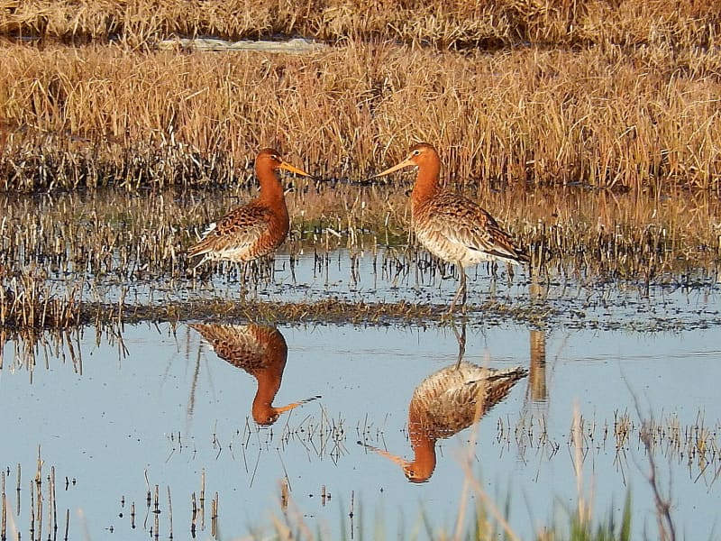
The Flói Bird Reserve
Northwest to the town of Eyrarbakki is a wetland area, rich in birdlife. The reserve has walking paths and a bird hide, an ideal spot for bird watching. The Flói Bird Reserve is listed in the Bird Life international Association. The Reserve is characterized by its flood meadows and numerous small ponds. Approximately 70 species of birds have been recorded in the Reserve. During spring and autumn migration Greylag Geese and White-fronted Geese can be found as well as Wigeon and Tufted Duck and various waders such as Snipe and passerines like Wheatear. During winter, birds, chiefly gulls and sometimes Long-tailed Duck and Common Eider, are concentrated in the estuary of the river Ölfusá. Whooper Swan, Teal, Mallard and Goosander are attracted to open water in winter.
View

Lækjargarður
Lækjargarður is a delightful outdoor recreation area situated in the village of Flúðir in South Iceland. Nestled beside a gentle stream and surrounded by lush greenery, the park offers a peaceful, family-friendly environment where nature and community converge.
The park boasts a variety of amenities catering to visitors of all ages. Children can enjoy the large jumping pillow and a thrilling zipline, providing endless fun and excitement. For sports enthusiasts, there's a beach volleyball court and a frisbee golf course, perfect for friendly competitions and outdoor exercise. Picnic areas and grassy lawns invite relaxation and social gatherings, while the stream adds a tranquil ambiance to the setting.
Adding an element of adventure, Lækjargarður features the Spot the Owl trail, a playful activity where visitors can search for owl figures hidden along the walking paths. This activity engages both children and adults in a fun exploration of the park.
View