Shimmering ice caps and flowing outlet glaciers define the skyline. Explore viewpoints, lagoons, and seasonal ice formations that show the region’s living geology.
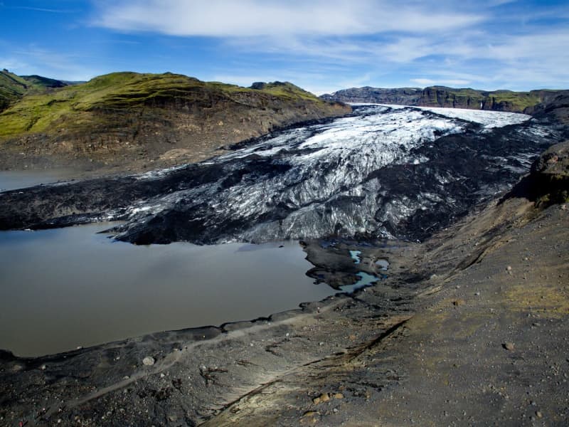
Sólheimajökull
Sólheimajökull is an outlet glacier that descends from the southwest corner of Mýrdalsjökull. It is a so-called "climate glacier" responding quickly to climate change. Access to the glacier tongue is good because it reaches down to the lowlands, and possible to go hiking on the glaciers with tour operators from the parking lot.
Large and rapid changes have taken place on the glacier in recent years, and one clear example of this is the increased distance required to approach the glacier trail.
Sólheimajökull has long been a research topic for glaciologists. Still, glacier research can tell us much about climate and climate change over the centuries. Still, the glacial history of Sólheimajökull is in many ways unusual compared to other Icelandic glaciers.
Over a hundred years ago, the glacial footprints of the Sólheimajökull glacier lay considerably in front of the current car park.
View
Heinaberg
Heinaberg is a beautiful area that consists of Heinabergsjökull glacier, the glacial lagoon Heinabergslón, where you can go kayaking among the icebergs during summer, and stunning landscape. The Heinaberg area is part of Vatnajökull National Park.
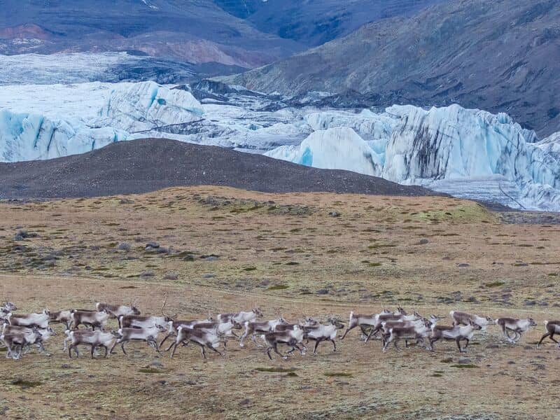
The gorgeous glacial lagoon of Heinaberg, Heinabergslón, is accessible by car and is often studded with large chunks of glacier that break off the Heinabergsjökull glacier. The area offers excellent conditions for hikers, as it has several interesting hiking trails, along which one can see waterfalls, ravines, volcanic intrusions, and even, on a lucky day, a reindeer.
The gravel road from road no 1 to the glacial lake is not in service during the winter months. Therefore, one needs to be aware of changes in road conditions and accessibility.
Vatnajökulsþjóðgarður
View
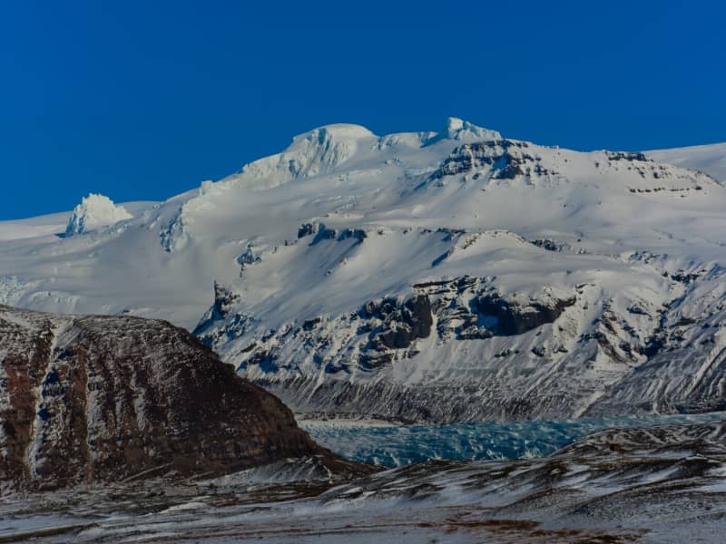
Öræfajökull glacier
Öræfajökull: Iceland’s highest mountainExtending south from the Vatnajökull icecap within Vatnajökull National Park and towering to around 2,110 m (6,922 feet), Öræfajökull is Iceland’s highest mountain. Its height actually varies with the season and the depth of snow and ice, since the peak itself, Hvannadalshnjúkur, is topped by ice which is thickest in spring and thinnest in autumn.
The mountain and surrounding areas offer good skiing in winter and are very popular with walkers and hikers throughout the year.
Vatnajökulsþjóðgarður
View

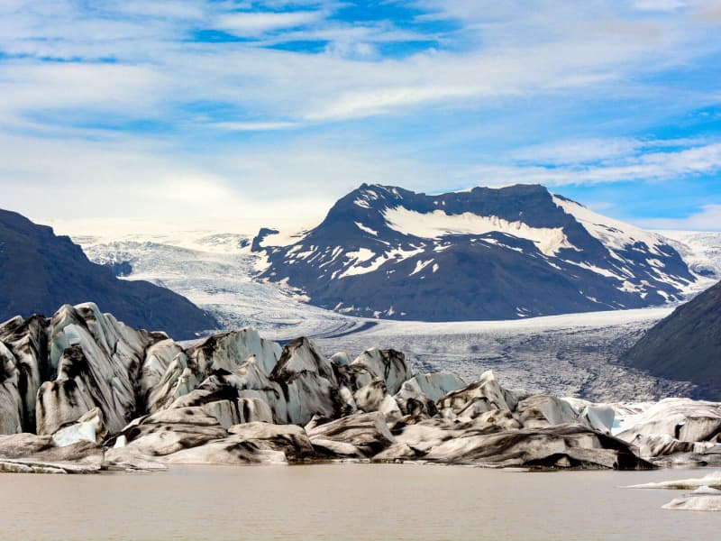
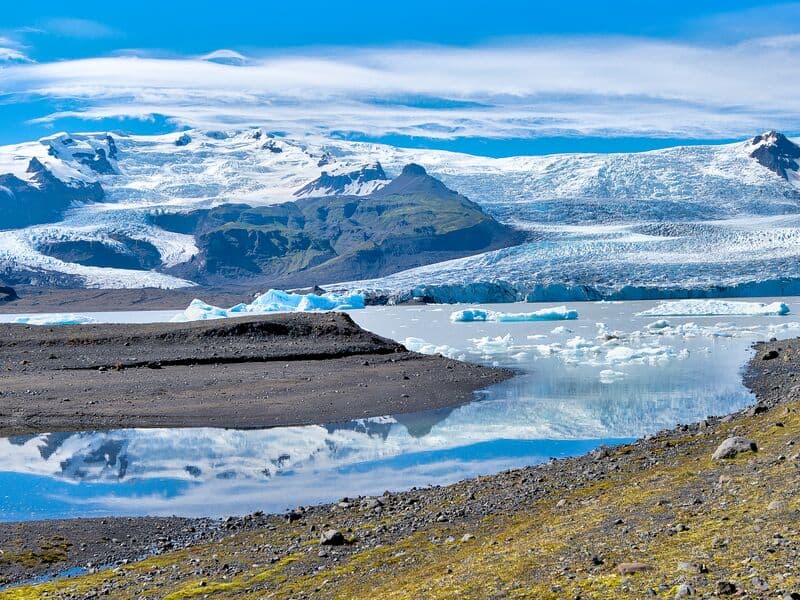
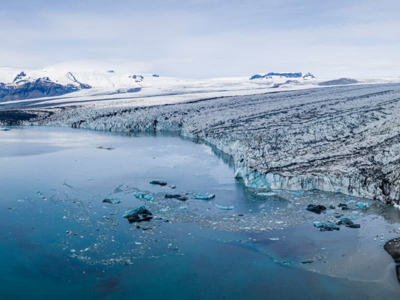
Jökulsárlón glacial lagoon
Jökulsárlón is a glacial lagoon beside the Ring Road, within Vatnajökull National Park. It is fed by Breiðamerkurjökull, an outlet glacier of Vatnajökull, and is known for the icebergs that drift across the lagoon before floating towards the Atlantic Ocean.
The area is one of the most popular stops in South Iceland, with views of blue-tinted ice, the glacier edge, and the nearby black sand beach where ice is often washed ashore. Seals can sometimes be seen in the lagoon or resting on the ice, but sightings vary by season and conditions.
Jökulsárlón is accessible year-round from Road 1, and there is a café by the lagoon. Visitors can also follow a marked hiking trail between Jökulsárlón and Fjallsárlón. Never step onto floating ice in the lagoon, as it can roll over or break apart without warning.
Vatnajökulsþjóðgarður
View
Eyjafjallajökull Glacier
The Eyjafjallajökull glacier is a 1651 m high glacier-capped stratovolcano. It is one of the smaller glaciers of Iceland. It is situated to the north of Skógar and to the south and west of the bigger glacier Mýrdalsjökull. The icecap of the glacier covers a volcano (1651m in height) that has erupted relatively frequently since the Ice Age. The crater of the volcano has a diameter of 3-4 km and the glacier covers an area of about 100 km². In June 1994 an earthquake swarm lasting for nearly a month occurred below the active volcano Eyjafjallajökull in South Iceland. It is otherwise a relatively quiet volcano – although it is not listed as being inactive. Eyjafjallajökull erupted in 1821-1823. The south end of the mountain was once part of the Atlantic coastline. As the sea has since retreated some 5 km, the former coastline has left behind sheer cliffs with a multitude of beautiful waterfalls, the best known of them being Skógafoss and Seljalandsfoss. In strong winds, the water of some of the smaller falls can even be blown up the mountain. It is one of the three glaciers that surround the Thorsmörk area - the other 2 being Myrdalsjökull and Tindfjallajökull. Specialized tours are arranged on the glacier for both skiing, super jeep tour, and hiking. One should never venture onto the glacier without guides and good knowledge of this kind of activity as this is a very dangerous area for inexperienced visitors.
Eyjafjallajökull featured prominently in world news in 2010 when ash from its eruption halted air traffic in Europe. An ice cap with several outlet glaciers covers the caldera of Eyjafjallajökull with a crater diameter 3-4 km wide. The outlet glaciers, Steinholtsjökull and Gígjökull, descend from the main glacier and can be visited by 4x4 trucks along the F-road to Þórsmörk. The area between the glaciers Eyjafjallajökull and Mýrdalsjökull with volcanic craters, Magni and Móði, created in the first stage of the Eyjafjallajökull eruption in April 2010.
View
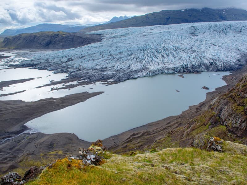
Fjallsárlón glacial lagoon
Fjallsárlón is a glacial lagoon at the southern edge of Vatnajökull glacier, about 10 km west of Jökulsárlón Glacier Lagoon. The lagoon lies within Vatnajökull National Park and is reached from Road 1.
The lagoon sits below Fjallsjökull, a steep glacier tongue that descends from Vatnajökull into the water. Visitors can stop for views of the glacier, floating ice, and the surrounding moraine landscape. Fjallsárlón is often a quieter alternative to nearby Jökulsárlón, although conditions and visitor numbers vary by season.
Boat tours are available on the lagoon, and there is a bistro on site. As with all glacier areas, visitors should stay on marked paths, keep away from unstable ice, and check local conditions before traveling in winter.
View
Langjökull Glacier
Langjökull is the country's second-largest glacier. Its accessibility is as good as it gets; however, no one should attempt driving up a glacier on their own. Many agencies offer tours that take you up the glacier in specially equipped vehicles with experienced glacier guides. You can choose from jeep excursions, glacier hiking, and snowmobiling.
View
Mýrdalsjökull glacier and Katla
Mýrdalsjökull Glacier and Katla VolcanoMýrdalsjökull is a glacier located in the south of Iceland. It is situated to the north of Vík í Mýrdal and the east of the smaller glacier Eyjafjallajökull. Its peak reaches 1493 m in height, and in 1980, it covered an area of 595 km². The view on a clear day is one of the prettiest in the world.
Guided snow scooters, snowmobiles, Super Jeep, and ice-climbing tours are offered on the Myrdalsjökull glacier. Travelers on the glacier must be cautious about crevasses, and inexperienced travelers should not go alone. Weather conditions shift rapidly high winds, and snowstorms can appear in a flash all year round.
The volcano Katla in the Mýrdalsjökull glacier, the volcano Katla erupts on average every 40 - 60 years. Sixteen eruptions have been recorded since the settlement of Iceland, the last in 1918, but there have probably been more. Katla is one of the most famous volcanoes in the country, and its eruptions usually have very serious consequences. It can be regarded as one of the most powerful volcanoes in the world and probably the largest active volcano in the northern hemisphere.
During the eruption, the glacier above the volcanic vent melts, and the melted water collects under the ice cap until it makes its way out under the edge in a violent flood. These are called "jokulhlaup."The floodwater carries huge amounts of ice, rocks, silt, and sand. Most of the Mýrdalssandur sand plain has been formed by deposits in past floods.
Katla has been showing signs of unrest recently, and some geologists suspect it might erupt soon since it is way overdue to erupt.
Eruptions of Katla have taken place (since known and recognized human settlement): 1918, 1860, 1823, 1755-56, 1721, 1660-61, 1625, 1612, 1580, 1416, 1357, 1311, 1262, 1245, 1177, 950.
View
Vatnajökull Glacier
Vatnajökull is the largest glacier in Iceland and the largest glacier by volume in Europe. It covers approx 8 percent of Iceland, measuring an area of 7,700 km² (2021), with an average thickness of 400 m, and the highest point, Hvannadalshnjúkur, measures 2,110 m (6,921 ft.). Vatnajökull has around 30 outlet glaciers flowing from the ice cap, all of which bear a name; glaciers and outlet glaciers all have names that end in "jökull" in Icelandic.
Vatnajökull belongs to the Vatnajökulþjóðgarður (Vatnajökull National Park) and covers a large area surrounding the glacier, including the glacier itself. In 2019, Vatnajökull National Park was inscribed on the UNESCO World Heritage List. The National Park offers numerous exciting sites and is a must for all interested in Geology and beautiful, natural vistas.
View
Hoffell
Hoffell is a farmland and glacier area about 20 km from Höfn in southeast Iceland, and partially within Vatnajökull national park. The area is known for Hoffellsjökull, an outlet glacier of Vatnajökull, as well as gabbro rock, geothermal water, rivers, outwash plains, and mountain views.
Visitors can explore several hiking routes around Hoffellsjökull and Geitafellsbjörg, with views of the glacier and its lagoon. From Road 1, a 3 km paved road leads to Hoffell Guesthouse and Hoffell geothermal Baths.
To reach the Hoffellsjökull car park, visitors continue along a 4 km gravel road. The road is rough and can be difficult for ordinary cars, so a four-wheel-drive vehicle is recommended. Overnight stays are not allowed at the Hoffellsjökull car park, and hikers should check trail, road, and weather conditions before setting out.
View
Fláajökull Glacier
Fláajökull is an outlet glacier of Vatnajökull in the southern part of Vatnajökull National Park, about 40 km west of Höfn. The area can be reached from Road 1 via a side road between Hólmur and Lambleiksstaðir, then a 6 km gravel road to the car park.
The glacier and surrounding landscape clearly show how ice has shaped the lowlands over time. Fláajökull reached its greatest known extent in 1894, after centuries of glacier advance during the colder period known as the Little Ice Age. Today, visitors can explore marked routes and information panels about the area’s history and geology.
There is also access from Haukafell forestry , with a footpath leading towards Fláajökull. Overnight stays are not allowed at the Fláajökull car park, and visitors should check road, trail, and weather conditions before traveling.
View