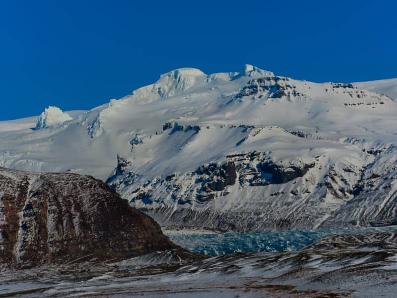
Vatnajökull Glacier
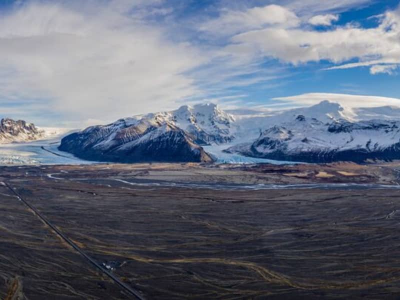
Vatnajökull is the largest glacier in Iceland and the largest glacier by volume in Europe. It covers approx 8 percent of Iceland, measuring an area of 7,700 km² (2021), with an average thickness of 400 m, and the highest point, Hvannadalshnjúkur, measures 2,110 m (6,921 ft.). Vatnajökull has around 30 outlet glaciers flowing from the ice cap, all of which bear a name; glaciers and outlet glaciers all have names that end in "jökull" in Icelandic.
Vatnajökull belongs to the Vatnajökulþjóðgarður (Vatnajökull National Park) and covers a large area surrounding the glacier, including the glacier itself. In 2019, Vatnajökull National Park was inscribed on the UNESCO World Heritage List. The National Park offers numerous exciting sites and is a must for all interested in Geology and beautiful, natural vistas.
View
Skeiðarársandur
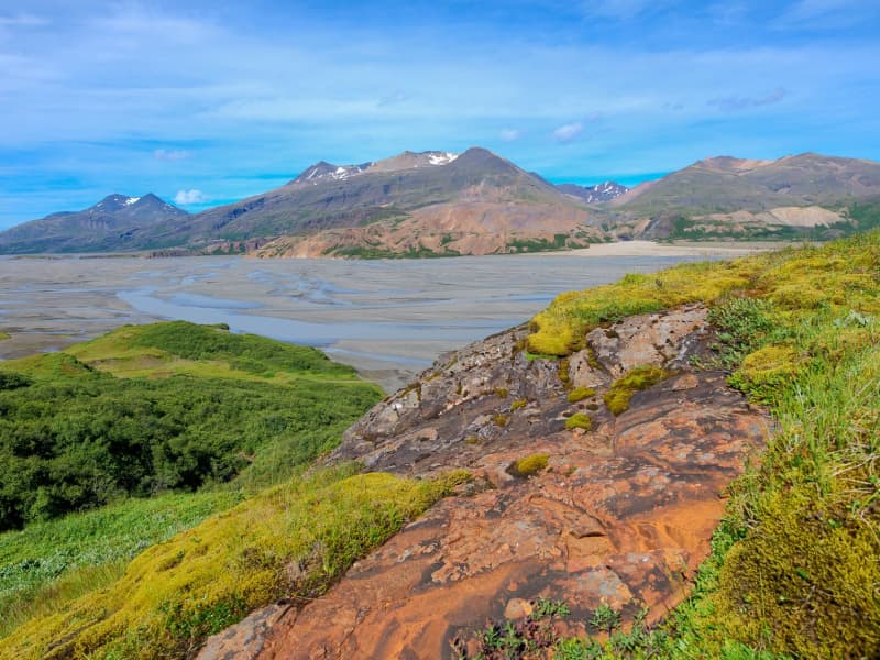
Skeiðarársandur is a large area of black sands, reaching from Skeiðarárjökull (a part of Vatnajökull) and to the sea. It covers an area of 1300 km² and was formed as the glacial rivers in the area washed material towards the sea. The rivers bring forth material that surfaced during sub-glacial volcanic eruptions in Vatnajökull. Near the glacier, the ground is gravelly and even rocky; as it reaches the sea, it has turned into sand and clay. There used to be little vegetation found on Skeiðarársandur, but in the past decade, a self-sprouted forest of birch trees has been growing lushly in the middle of the area. Skeiðarársandur is a large nesting area for the great skua.
Skeiðarárbrú Skeiðarárbrú is the name of the bridge that crosses the Skeiðará river on Skeiðarársandur, and its opening in 1974 marked the opening of the ring road in Iceland. Skeiðarárbrú is a one-lane bridge made of specifically engineered steel trusses. In 1996 there was a volcanic eruption in Grímsvötn in Skeiðarárjökull, which created massive floods and glacier melting. The hefty amount of floodwaters and house-sized icebergs severely damaged the bridge. All that remains of the original bridge today are two twisted girders by the side of the new road. They form a unique monument to Iceland's natural landscape's lovely but powerful beauty. The bridge has been replaced with a new one due to changes in the water flow underneath the glacier. The river flowing under the new bridge is called Morsá.
View
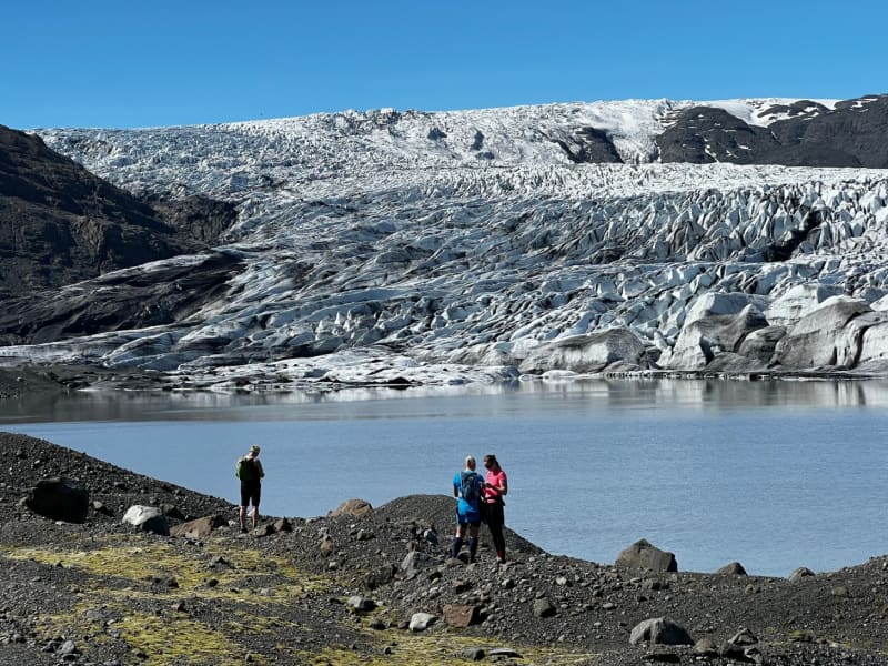
Skaftafell
Scenic nature, favorable weather conditions, and a network of hiking trails make Skaftafell in Vatnajökull National Park an ideal destination to enjoy outdoor activities in Icelandic nature. Short and easy trails lead to the waterfall Svartifoss and Skaftafellsjökull glacier. Still, those who want to reach further out Morsárdalur valley and Kristínartindar mountain peaks are perfect in terms of distance and labor. Skaftafell is also the ideal base camp for those who seek to climb Iceland‘s highest mountain peak, Hvannadalshnúkur.
During the summer months, the national park offers interpretive tours with rangers. Ask for information at the desk or check the park´s website.
Private travel companies operate in Skaftafell and offer guided hikes on the nearby glaciers and mountains. Also on offer are sightseeing flights over the Vatnajökull glacier and other renowned attractions.
Vatnajökulsþjóðgarður
View
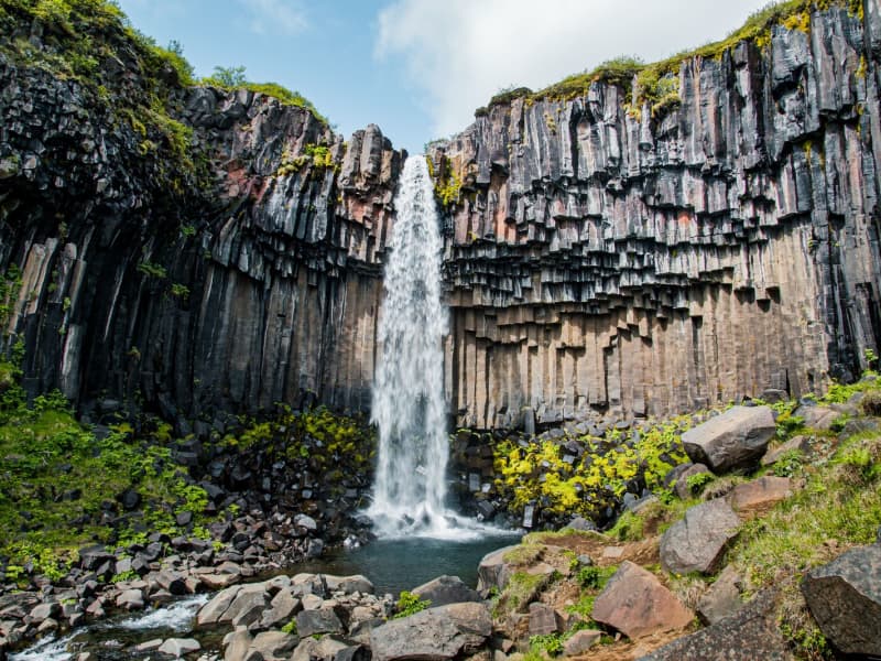
Svartifoss waterfall
Svartifoss is one of the unique waterfalls in South Iceland. It is situated in Skaftafell, which belongs to Vatnajökull National Park. Svartifoss is 20 meters (80ft) high. It is bordered on both sides by tall black basalt columns.
The hike to Svartifoss starts at the Visitor Centre in Skaftafell. You can also find all sorts of information and advice about the area. The hike is about 1.9 km or 45 minutes (one way).
Skaftafell Visitor Centre, Skaftafell
View
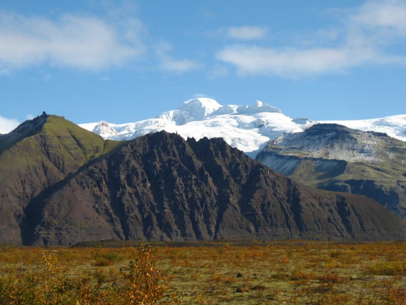
Öræfajökull glacier
Öræfajökull: Iceland’s highest mountainExtending south from the Vatnajökull icecap within Vatnajökull National Park and towering to around 2,110 m (6,922 feet), Öræfajökull is Iceland’s highest mountain. Its height actually varies with the season and the depth of snow and ice, since the peak itself, Hvannadalshnjúkur, is topped by ice which is thickest in spring and thinnest in autumn.
The mountain and surrounding areas offer good skiing in winter and are very popular with walkers and hikers throughout the year.
Vatnajökulsþjóðgarður
View
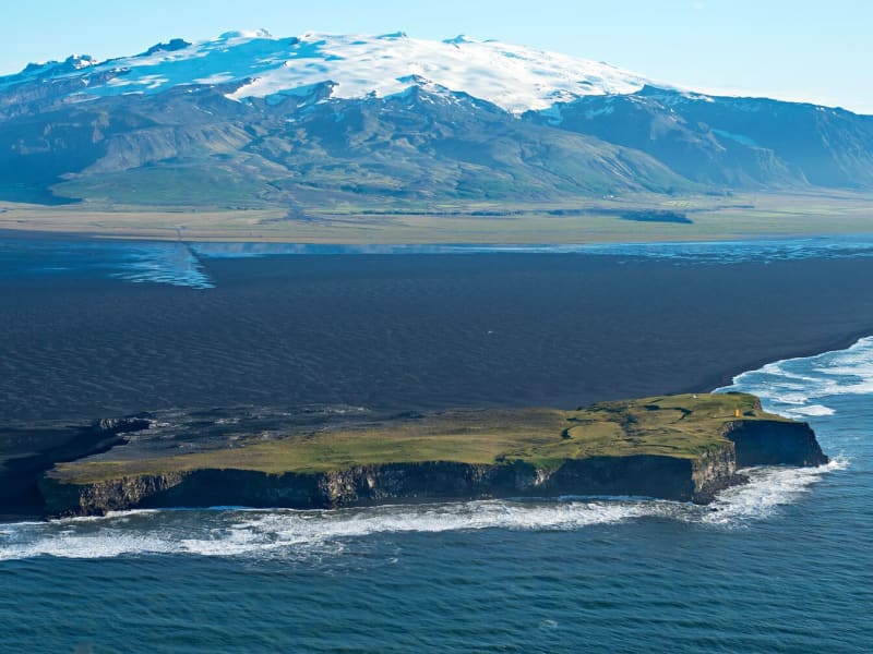
Ingólfshöfði
At the edge of the Atlantic Ocean, Ingólfshöfði is a headland isolated by black sands and perilous rivers from the rest of the mainland.
This historical cape is named after the first settler of Iceland, Ingólfur Arnarson, who spent his first winter there with his family after moving to Iceland, 874-875 A.D.
However, it´s home to thousands of nesting seabirds and gulls, especially puffins and the great skua. Ingólfshöfði is only accessible by organized tours.
View
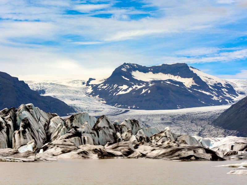
Fjallsárlón glacial lagoon
Fjallsárlón is a glacial lagoon at the southern edge of Vatnajökull glacier, about 10 km west of Jökulsárlón Glacier Lagoon. The lagoon lies within Vatnajökull National Park and is reached from Road 1.
The lagoon sits below Fjallsjökull, a steep glacier tongue that descends from Vatnajökull into the water. Visitors can stop for views of the glacier, floating ice, and the surrounding moraine landscape. Fjallsárlón is often a quieter alternative to nearby Jökulsárlón, although conditions and visitor numbers vary by season.
Boat tours are available on the lagoon, and there is a bistro on site. As with all glacier areas, visitors should stay on marked paths, keep away from unstable ice, and check local conditions before traveling in winter.
View

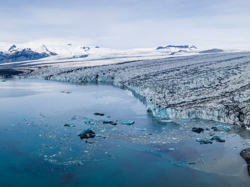
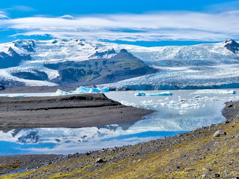
Jökulsárlón glacial lagoon
Jökulsárlón is a glacial lagoon beside the Ring Road, within Vatnajökull National Park. It is fed by Breiðamerkurjökull, an outlet glacier of Vatnajökull, and is known for the icebergs that drift across the lagoon before floating towards the Atlantic Ocean.
The area is one of the most popular stops in South Iceland, with views of blue-tinted ice, the glacier edge, and the nearby black sand beach where ice is often washed ashore. Seals can sometimes be seen in the lagoon or resting on the ice, but sightings vary by season and conditions.
Jökulsárlón is accessible year-round from Road 1, and there is a café by the lagoon. Visitors can also follow a marked hiking trail between Jökulsárlón and Fjallsárlón. Never step onto floating ice in the lagoon, as it can roll over or break apart without warning.
Vatnajökulsþjóðgarður
View
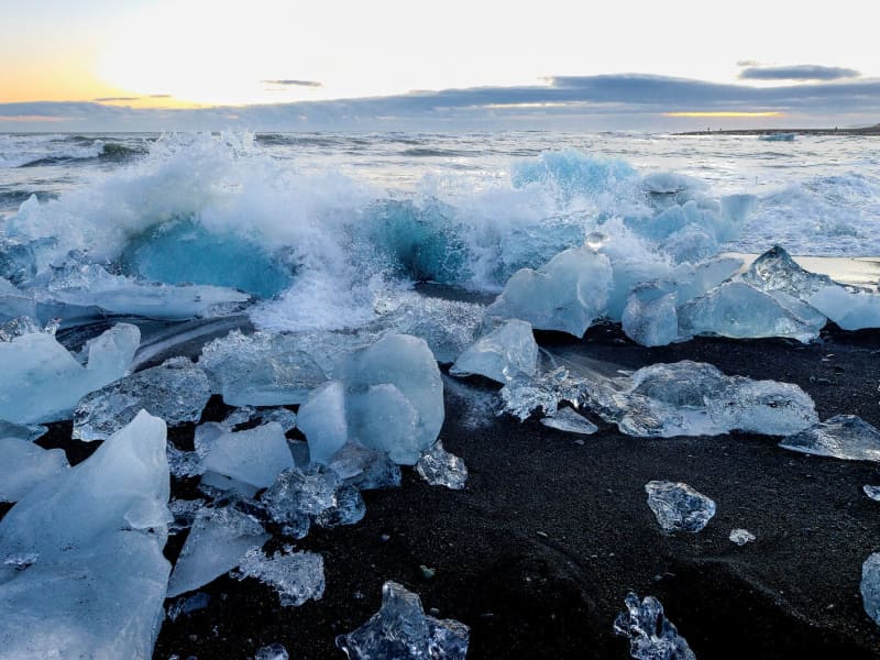
Breiðamerkursandur - Fellsfjara
Fellsfjara is a black-sand beach next to Jökulsárlón Glacier Lagoon, within Vatnajökull National Park. Ice from the glacial lagoon is carried by the river towards the sea, then washed back onto the beach by the tides.
The scattered ice pieces across the black sand make the area a popular spot for photography, especially when the light reflects through the ice. Conditions change with the tide, weather, and season, so the amount and position of ice on the beach vary.
The name Breiðamerkursandur refers to the large glacial outwash plain south of the glacier Breiðamerkurjökull. Fellsfjara refers to the coastline itself. The place has been nicknamed The Diamond Beach by international visitors.
Visitors should take care near the shoreline. Never climb onto the ice, stay away from ice close to the sea, and always keep watch for waves, which can come in unexpectedly.
View
Skálafell – Hjallanes
Skálafell–Hjallanes is a hiking area between Jökulsárlón Glacier Lagoon and Höfn in Hornafjörður, within Vatnajökull National Park. The area gives visitors access to marked walking paths and glacier views in a quieter part of southeast Iceland.
One of the main routes is an 8 km circular hike through the Hjallanes area, leading towards the edge of Vatnajökull glacier. A walking bridge over the river Kolgríma also connects Skálafell with the Heinaberg hiking area, opening up more routes for visitors who want to explore the glacial landscape on foot.
Skálafell is close to Road 1 and can be a good stop for travellers driving between Jökulsárlón and Höfn. Check trail and weather conditions before setting out, and allow around 3–4 hours for the circular hike.
More trail information: Vatnajökull National Park
View
Heinaberg
Heinaberg is a beautiful area that consists of Heinabergsjökull glacier, the glacial lagoon Heinabergslón, where you can go kayaking among the icebergs during summer, and stunning landscape. The Heinaberg area is part of Vatnajökull National Park.
The gorgeous glacial lagoon of Heinaberg, Heinabergslón, is accessible by car and is often studded with large chunks of glacier that break off the Heinabergsjökull glacier. The area offers excellent conditions for hikers, as it has several interesting hiking trails, along which one can see waterfalls, ravines, volcanic intrusions, and even, on a lucky day, a reindeer.
The gravel road from road no 1 to the glacial lake is not in service during the winter months. Therefore, one needs to be aware of changes in road conditions and accessibility.
Vatnajökulsþjóðgarður
View
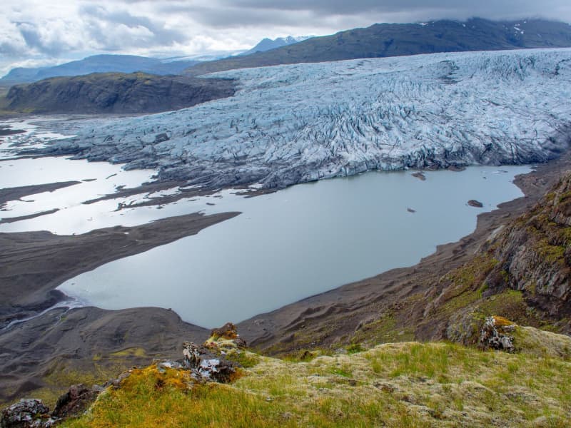
Fláajökull Glacier
Fláajökull is an outlet glacier of Vatnajökull in the southern part of Vatnajökull National Park, about 40 km west of Höfn. The area can be reached from Road 1 via a side road between Hólmur and Lambleiksstaðir, then a 6 km gravel road to the car park.
The glacier and surrounding landscape clearly show how ice has shaped the lowlands over time. Fláajökull reached its greatest known extent in 1894, after centuries of glacier advance during the colder period known as the Little Ice Age. Today, visitors can explore marked routes and information panels about the area’s history and geology.
There is also access from Haukafell forestry , with a footpath leading towards Fláajökull. Overnight stays are not allowed at the Fláajökull car park, and visitors should check road, trail, and weather conditions before traveling.
View
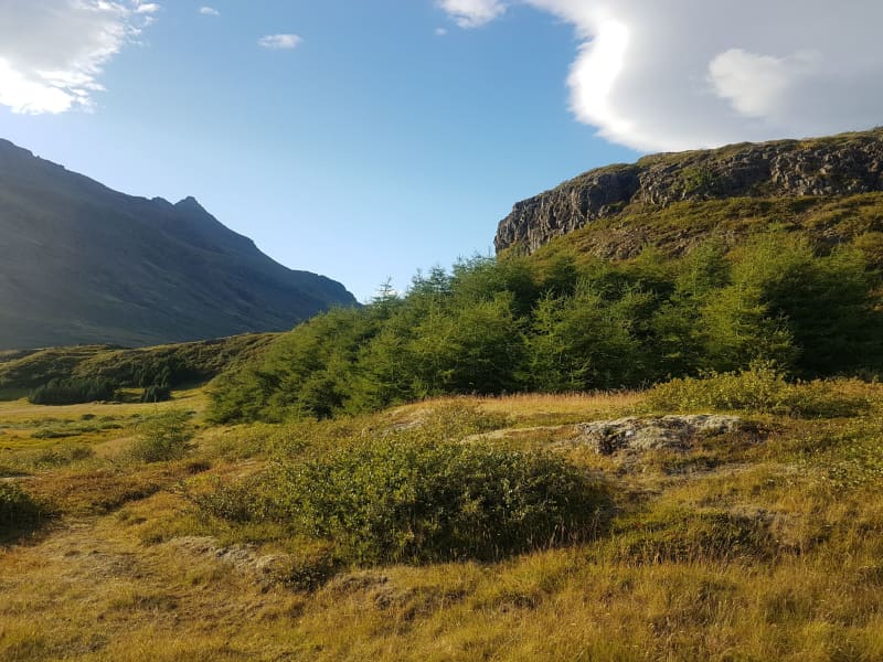
Haukafell
Haukafell is a forestry and outdoor recreation area east of Fláajökull glacier in southeast Iceland. The forestry project began in 1985 and now provides shelter for low-growing vegetation, including berry bushes that are usually ripe in August.
The area is used by locals and visitors for hiking and nature enjoyment. Several trails lead through the sheltered landscape, and a marked hiking route connects Haukafell with Fláajökull, crossing the Kolgrafardalsá river on a footbridge.
Haukafell is close to Road 1 and has a campsite in a scenic setting. Visitors planning to hike towards Fláajökull should check the weather and trail conditions before setting out, as conditions can change quickly near glacier areas.
View
Hoffell
Hoffell is a farmland and glacier area about 20 km from Höfn in southeast Iceland, and partially within Vatnajökull national park. The area is known for Hoffellsjökull, an outlet glacier of Vatnajökull, as well as gabbro rock, geothermal water, rivers, outwash plains, and mountain views.
Visitors can explore several hiking routes around Hoffellsjökull and Geitafellsbjörg, with views of the glacier and its lagoon. From Road 1, a 3 km paved road leads to Hoffell Guesthouse and Hoffell geothermal Baths.
To reach the Hoffellsjökull car park, visitors continue along a 4 km gravel road. The road is rough and can be difficult for ordinary cars, so a four-wheel-drive vehicle is recommended. Overnight stays are not allowed at the Hoffellsjökull car park, and hikers should check trail, road, and weather conditions before setting out.
View
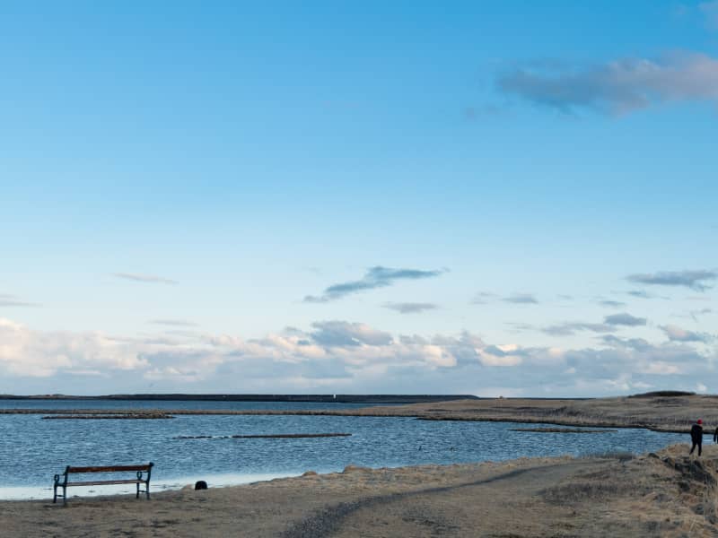
Ósland
Ósland is a conservation area by the harbour in Höfn, connected to the mainland by a man-made land bridge. The area is well suited for a short walk, with trails around Óslandstjörn pond and along the shoreline.
Ósland has rich birdlife, especially during the nesting season when Arctic terns are common. Visitors can also see Óslandshæð, a hill with a memorial to fishermen and an information board about the local nature.
A nature trail in the area presents the solar system at a reduced scale, showing the planets in proportion to their size and distance. Basalt rock in Ósland also contains visible impressions of ancient trees that were covered by lava.
View
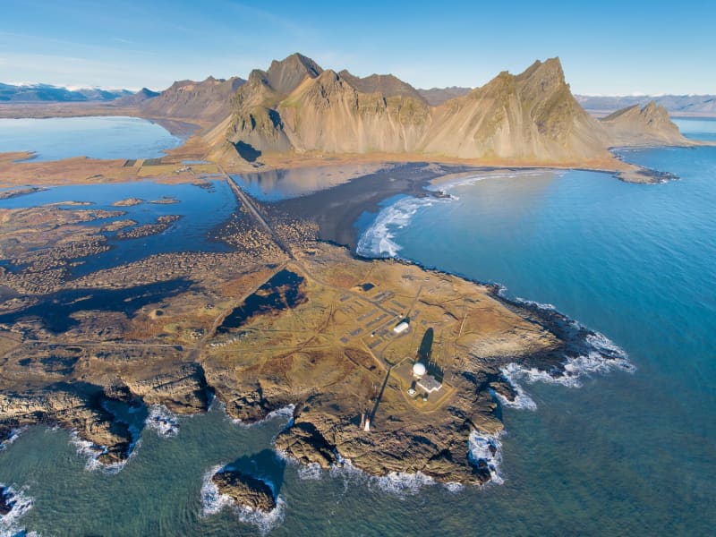
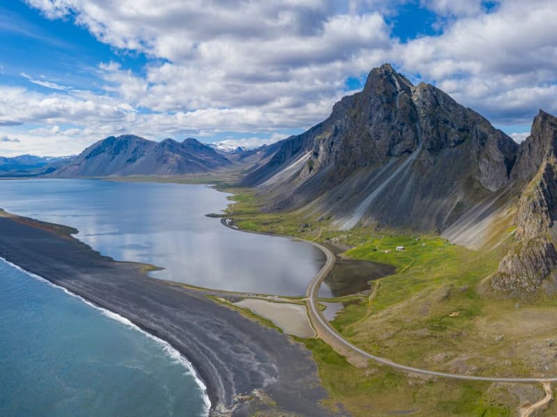
Vestrahorn
Vestrahorn is a 454-metre mountain on the Stokksnes peninsula, about a ten-minute drive from Höfn. The area is known for its dark sand beaches, rocky shoreline, and views of the mountain rising above the coast.
Vestrahorn is also a notable geological site, made mainly of gabbro with some granophyre. East of the mountain is Brunnhorn, a distinctive outcrop that extends towards the sea.
The area has historical connections to one of Iceland’s early settlement farms, Horn. During the Second World War, it was used as a British army base, and a NATO radar station was later built at Stokksnes. Visitors may also see seals on the sand, but sightings are not guaranteed.
View
Hvalnes
Hvalnes is a small peninsula with a black pebble beach stretching for a few kilometers. Sitting on its tip is a picturesque old, yellow lighthouse and an old turf farm with the same name as Hvalnes.
The beach stretches for a few kilometers and would make a nice walk, or you can hang out on the beach and enjoy the view. It is an excellent location for bird watching and photography.
View
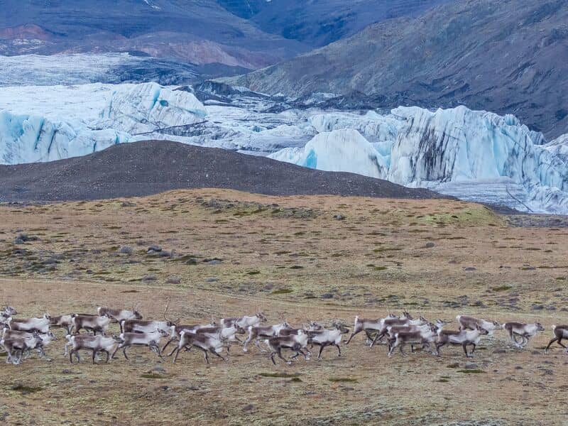
Lónsöræfi
In Lón District, the most eastern area of the Vatnajökull Region, lie the Stafafellsfjöll mountains, also called Lónsöræfi. They dominate the skyline east of the Vatnajökull glacier and have long comprised one of Iceland’s most extensive protected areas. Besides the deep, rugged canyons, the landscape displays a wide range of colors owing to the presence of rhyolite and other colorful rocks. In contrast, there are also lushly vegetated and sheltered valleys offering a very good chance of spotting reindeer. The numerous hiking trails make this area perfect for hiking. Keep in mind that getting there can be very difficult and one should seek advice from a visitor- or information center before attempting to go there.
View