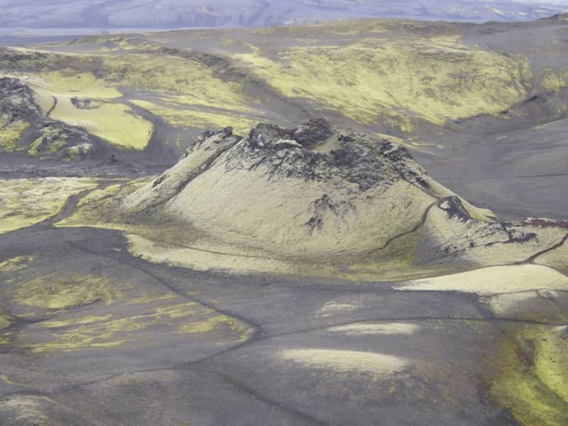
Lakagígar and Laki
Lakagígar is a row of craters formed in one of the world's largest mixed eruptions in recorded history. This continuous series of eruptions emitted a vast quantity of lava and substantial amounts of volcanic ash from a fissure stretching 25 km across the area west of the ice cap. The craters are regarded as a globally unique phenomenon and are, as such, protected within Vatnajökull National Park.
In 1783, a huge lava flow streamed from Lakagígar in what became known as the "Skaftá Fires." This is believed to have been one of the greatest lava flows in a single eruption in the history of the world: the molten lava filled the gorges through which the Skaftá and Hverfisfljót rivers flowed and swept down in two branches into inhabited areas, to spread over the lowlands where it laid waste many farms. The eruption produced large quantities of volcanic ash. For residents of the region and Iceland as a whole, the results of the eruption were catastrophic: this time is known as "Móðuharðindin" (the Haze Famine).
All roads in the western part of the national park are mountain tracks, only navigable for vehicles with four-wheel-drive; some only for large jeeps. Some sections of the road are rocky and full of potholes, and loose gravel is common. It is sometimes necessary to ford (drive through) streams and rivers which can become suddenly swollen, making them difficult, or even impossible, to cross. It is dependent on the weather when the roads are opened. Usually, they are open from early June through to autumn. Driving is only allowed on the roads marked on the accompanying map. All other roads or tracks are closed to the public. Here, as elsewhere in Iceland, driving off-road is banned by law.
View
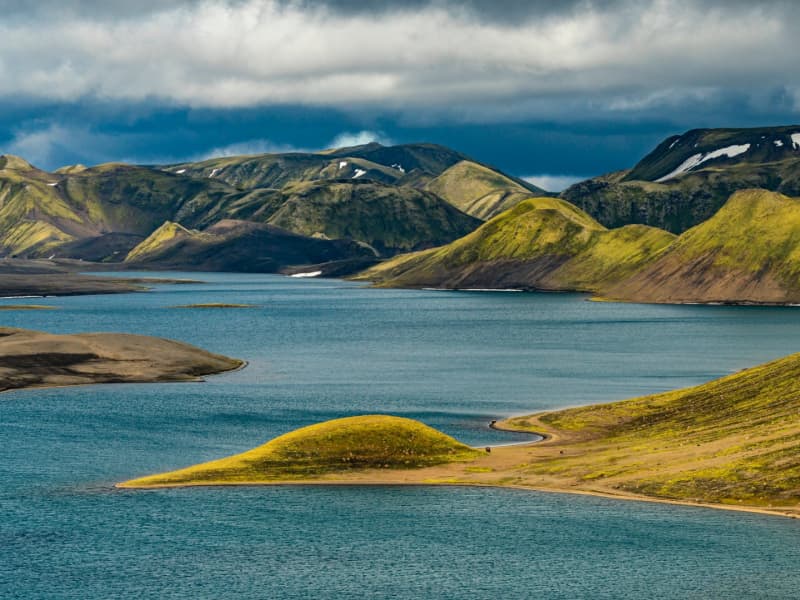
Langisjór Lake, Fögrufjöll, Grænifjallgarður
Langisjór is a lake within Vatnajökull National Park that's 20 km long and 2 km wide in some places. The lake is to the southwest of Vatnajökull, between the mountains Tungnárfjöll and Fögrufjöll, in a beautiful and picturesque landscape. Its square measure is 27 km², it reaches a depth of 75 m, and the water surface is 670 m above s
Langisjór is reached by the mountain road Fjallabaksleið nyrðri (F 208), west of Kirkjubæjarklaustur. All roads in the western part of the national park are mountain tracks, only navigable for vehicles with four-wheel-drive; some only for large jeeps. Some sections of the road are rocky and full of potholes, and loose gravel is common. It is sometimes necessary to ford (drive through) streams and rivers, which can suddenly become swollen, making them difficult or even impossible to cross. It is dependent on the weather when the roads are open. Usually, they are open from early June through to the autumn. Driving is only allowed on the roads marked on the accompanying map. All other roads or tracks are closed to the public. Here, as elsewhere in Iceland, driving off-road is banned by law.
View
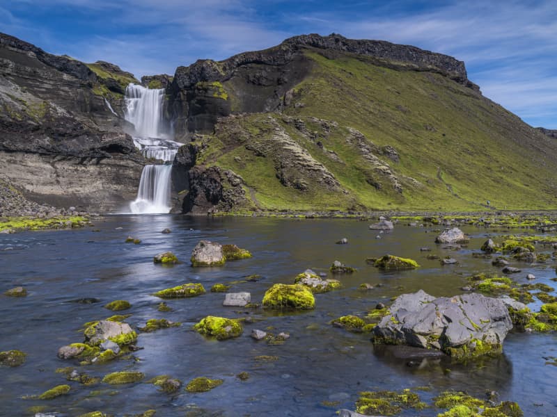
Eldgjá canyon
Eldgjá is an old tectonic graben reactivated in a massive eruption in 934-940. The Eldgjá vents form a discontinuous 75 km long volcanic fissure extending from the Katla volcano in the west to Vatnajökull in the east. The eruption in 934-940 takes its name from a spectacular 150 m deep and 8 km long chasm called Eldgjá (fire fissure) that occupies the central part of the vent system. Part of the fissure is under the protection of the Vatnajökull National Park. There you can take a walk along the bottom of the fissure and witness the sheer scale of it. An easy hike takes you from the car park (with WC facilities) along the bottom of the fissure to Ófærufoss waterfall. Getting there: you need a 4x4, and the area is only accessible in the summer. Eldgjá is a site of international geological significance. Ófærufoss is a distinctive two-tiered waterfall cascading into the fissure Eldgjá.
Eldgjá is reached by the mountain road Fjallabaksleið nyrðri (F 208), west of Kirkjubæjarklaustur. All roads in the western part of the national park are mountain tracks, only navigable for vehicles with four-wheel-drive; some only for large jeeps. Some sections of the road are rocky and full of potholes, and loose gravel is common. It is sometimes necessary to ford (drive-through) streams and rivers, which can suddenly become swollen, making them difficult or even impossible to cross. It is dependent on the weather when the roads are opened. Usually, they are open from early June through to autumn. Driving is only allowed on the roads marked on the accompanying map. All other roads or tracks are closed to the public. Here, as elsewhere in Iceland, driving off-road is banned by law.
View
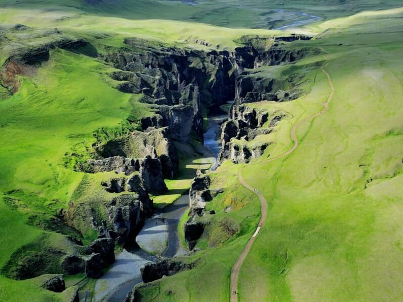
Fjaðrárgljúfur canyon
Fjaðrárgljúfur is 6 kilometers from Road 1; take road F206. People can travel by small cars to Fjaðrárgljúfur all year round. Fjaðrárgljúfur is a magnificent and massive canyon, about 100 meters deep and about two kilometers long. The canyon has sheer walls and is somewhat serpentine and narrow. The bedrock in Fjaðrárgljúfur is mostly palagonite from cold periods of the Ice Age and is thought to be about two million years old. The river Fjaðrá has its source in the mountain Geirlandshraun and falls off the heath edge in this stunning canyon until it makes it down into the Skaftá river. Fjaðrá has changed a lot over time.
Formation of the Fjaðrárgljúfur canyonIt is believed that Fjaðrárgljúfur was formed at the end of the last Ice Age, about nine thousand years ago. When the glacier retreated, a lake formed in the valley behind a hard, resistant rock. The run-off from the lake flowed to where Fjaðrárgljúfur is today. Glacial rivers from the glacier’s edge carried a lot of sediment into the lake, and the river which ran from it dug itself down into the rock and down onto the palagonite in front of it. Because the cascade was so large, it was powerful in digging out the canyon. Eventually, the lake filled with sediments, and the river’s strength dwindled. When the lake filled up completely, the river began to dig into the sediment layers it had previously left in the valley. Fluvial terraces on both sides of the valley indicate the original height and location of the lake while a deep channel in the palagonite serves as a silent reminder of the power of nature.
More geosites in the neighborhood: www.katlageopark.com
View
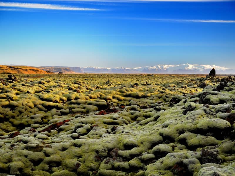
Skaftáreldahraun lava field
In 1783, a huge lava flow streamed from Lakagígar in what became known as the “Skaftá Fires.” This is believed to have been one of the greatest lava flows in a single eruption in the history of the world. The molten lava filled the gorges through which the Skaftá and Hverfisfljót rivers flowed, and swept down in two branches into inhabited areas, to spread over the lowlands where it laid waste many farms. Its cubic measure is estimated um 16km3 and the square measure of the lava is approximately 580km2.
In Skaftáreldahraun you find a good place to stop the car and take a look over the lava field shortly (4 km) before you arrive in Kirkjubæjarklaustur. There you find a car park and an information board.
View
Systrafoss Waterfall
Systrafoss is the name of the waterfall where the river Fossá falls from the lake Systravatn, over the mountain edge above Kirkjubæjarklaustur. Low down in the gorge, there's Fossasteinn, which fell from the mountain during a massive thunderstorm in 1830. A beautiful hiking trail leads to the top of the mountain and Systravatn. From the mountain edge, the view is breathtaking, and up there, you see the Golden Nugget, which aim is to recall the history of hydropower plants in Iceland. The Hiking trail, Ástarbrautin (Love Path), starts at Systrafoss. It is 5 km. And you can see Kirkjugólfið on the way.
The forest by Systrafoss is from 1945. Skógarstígurinn is a circular path in the forest where one stop is Sönghellir. The forest path is marked by the tallest tree in Iceland, a spruce almost 30 meters high.
View
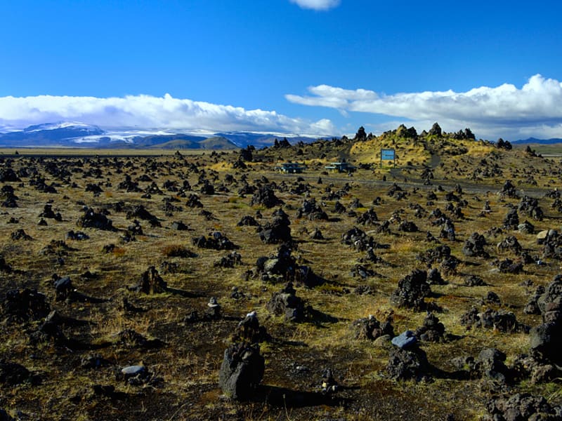
Laufskálavarða
Laufskálavarða is a lava ridge surrounded by stone cairns between the Hólmsá and Skálmá rivers, close to the road north of Álftaver. For the first time, all travelers crossing the desert of Mýrdalssandur for the first time were supposed to pile stones up to make a cairn, which would bring them good fortune on the journey.
At Laufskálavarða, you find a viewing platform to see Mýrdalsjökull, where Katla, the famous volcano, is located.
View
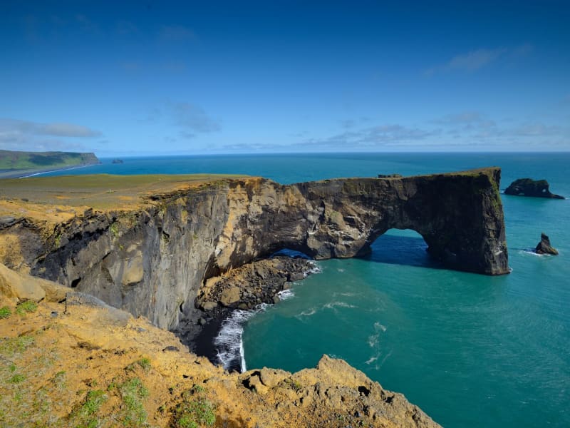
Dyrhólaey
Dyrhólaey is a nature reserve. The protected areas are necessary to ensure protection while ensuring public rights. Some areas are closed for part of the year to preserve wildlife, others are closed all year round due to sensitive natural monuments, traffic is also limited in some areas to people, and others are open all year round.
More information about DyrhólaeyDyrhólaey is a 120-meter high promontory not far from Vík. The place got its name from the massive arch that the sea has eroded from the headland. When the sea is calm, big boats can sail through it. A maniacal daredevil pilot has even flown through the arch with a small-craft airplane!
From the top of Dyrhólaey, there is a great view. The headland is thought to have been made in an underwater volcanic eruption late in the glacial period, not unlike the eruption of Surtsey. Several outcrops are in the sea; the highest one, called Háidrangur ("High column"), is 56 m. high. Dyrhólaey has been a natural reserve since 1978.
The promontory is widely known among sailors as "Portland" and English trawler fishermen beach where one can climb (at your own risk). According to legend, the Reynisdrangar needles were formed when two trolls tried dragging a three-masted ship to land. When daylight broke, they turned to stone. The Needles can be seen clearly from the village of Vík and are 66 meters above sea level at their highest.
In one of the many caves here – there is a local legend about a monster having lived here for many centuries. The monster seems to have disappeared after a landslide over 100 years ago…used to call it a "Blow hole." There are also unique rock formations all along the Birdlife here is abundant, with puffins and eider ducks being the most common species in the area. On top of the cliff, the lighthouse stands impressive and stoic in this often very windy area. Be careful not to go too close to the ledge of this dramatic cliff.
View
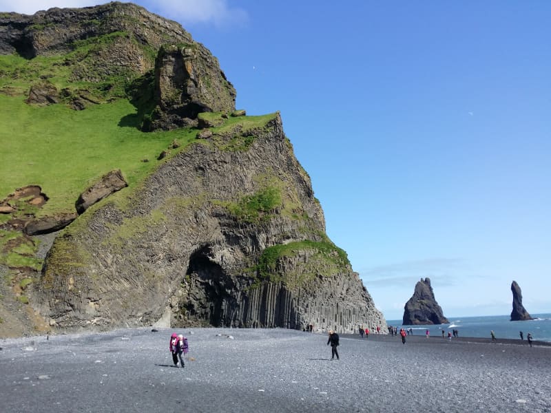
Reynisfjara, Reynisfjall og Reynisdrangar
Reynisfjall is a 340 m high tuff mountain arising out of a volcanic eruption from under a glacier in the penultimate Ice Age, near the village of Vik. Alternating in an irregular manner are layers of tuff, pillow lava and columnar basalt veins and loops.
Reynisdrangar stacks are a collection of 66 m high rock pillars that rise out of the sea and are of the same geological formation as Reynisfjall. On Reynisfjöru beach, very beautiful basalt formations in the south part of the mountain can be seen, and there you will find an exceedingly beautiful cave called Hálsanefshellir.
The waves here are deceiving and have caused the death of a number of visitors in recent years, even in the best of weather. Please take great care and keep a good distance from the sea.
View
Hjörleifshöfði
Hjörleifshöfði is a 220-meter tuya cliff. Tuya is a distinctive, flat-topped, steep-sided volcano formed when lava erupts through thick glaciers or ice sheets. Hjörleifshöfði is on the southwest side of Mýrdalssandur. It's believed it formed during the last cold period of the ice age when the eruption took place under the glacier. It was probably an island in the sea in the past but has become landlocked during the settlement period with a fjord called Kerlingarfjörður. Today it's surrounded by black sands that have collected after repeated glacial runs from Katla volcano.
South of Hjörleifshöfði, a spit is named after Katla and is called Kötlutangi - the Katla spit. It was formed from a large eruption in 1918 where an enormous amount of sediment came with a sizeable glacial run from Katla. Kötlutangi - the Katla spit was the southernmost point of mainland Iceland; before the eruption, it was Dyrhólaey.
Hjörleifshöfði gets its name from the settler Hjörleifur Hróðmarsson, Ingólfur Arnarson's stepbrother. They sailed in two ships on their way to Iceland but parted ways as Ingólfur spent the winter at Ingólfshöfði and his stepbrother at Hjörleifshöfði. Hjörleifur did not live long, but he was killed along with his men by Irish slaves who followed them to the country. They fled to the Westman Islands with the women, where Ingólfur found them and killed them. On Hjörleifshöfði is a mound where it's considered that Hjörleifur is buried.
Hjörleifshöfði was inhabited till 1936, there was a farm located in the southern part of it, but it was moved there after the eruption in Katla in 1721, which destroyed the old town. The old town is located by Katla UNESCO Global Geopark's destination when you reach Hjörleifshöfði on the west side.
View
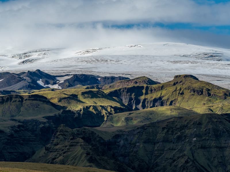
Mýrdalsjökull glacier and Katla
Mýrdalsjökull Glacier and Katla VolcanoMýrdalsjökull is a glacier located in the south of Iceland. It is situated to the north of Vík í Mýrdal and the east of the smaller glacier Eyjafjallajökull. Its peak reaches 1493 m in height, and in 1980, it covered an area of 595 km². The view on a clear day is one of the prettiest in the world.
Guided snow scooters, snowmobiles, Super Jeep, and ice-climbing tours are offered on the Myrdalsjökull glacier. Travelers on the glacier must be cautious about crevasses, and inexperienced travelers should not go alone. Weather conditions shift rapidly high winds, and snowstorms can appear in a flash all year round.
The volcano Katla in the Mýrdalsjökull glacier, the volcano Katla erupts on average every 40 - 60 years. Sixteen eruptions have been recorded since the settlement of Iceland, the last in 1918, but there have probably been more. Katla is one of the most famous volcanoes in the country, and its eruptions usually have very serious consequences. It can be regarded as one of the most powerful volcanoes in the world and probably the largest active volcano in the northern hemisphere.
During the eruption, the glacier above the volcanic vent melts, and the melted water collects under the ice cap until it makes its way out under the edge in a violent flood. These are called "jokulhlaup."The floodwater carries huge amounts of ice, rocks, silt, and sand. Most of the Mýrdalssandur sand plain has been formed by deposits in past floods.
Katla has been showing signs of unrest recently, and some geologists suspect it might erupt soon since it is way overdue to erupt.
Eruptions of Katla have taken place (since known and recognized human settlement): 1918, 1860, 1823, 1755-56, 1721, 1660-61, 1625, 1612, 1580, 1416, 1357, 1311, 1262, 1245, 1177, 950.
View
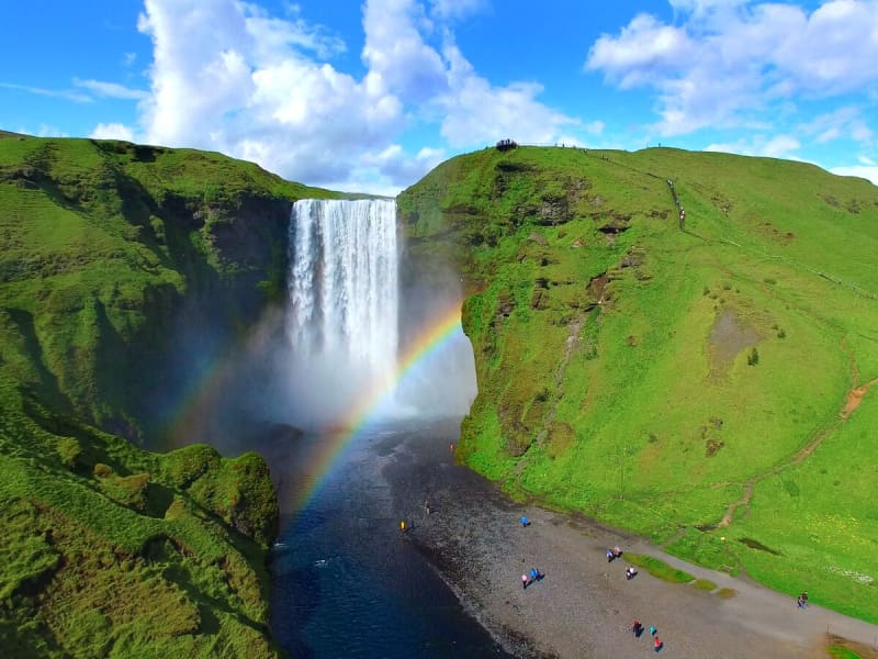
Skógafoss - Waterfall
Only a few kilometers away from the south shores of Iceland lies the village of Skógar along the Southern Ring Road. It is a popular summer resort center surrounded by unusual scenic beauty. The breathtaking view of Skogáfoss waterfall and picturesque surroundings and the snow-capped heights of two towering glaciers are Skógar's major summer attractions. There are two settlements by this name. One is Ytri-Skógar (outer or western Skógar) and the other Eystri-Skógar (eastern Skógar), located at a short distance from each other. Ytri-Skógar, commonly referred to as Skógar, is the main settlement. It is an old farm and has a church from 1890. It is located between the Skógá and Kverná rivers.
The greatest attraction of Skógar is, of course, the beautiful 60-meter high Skogáfoss waterfall in the river Skógá. Like the legends of buried treasures of Egill Skallagrímsson in Mosfell near Reykjavík and Ketilbjörn in Mosfell near Skálholt, there is a similar legend about the settler Þrasi who is believed to have buried his chest of gold under the Skogáfoss waterfall.
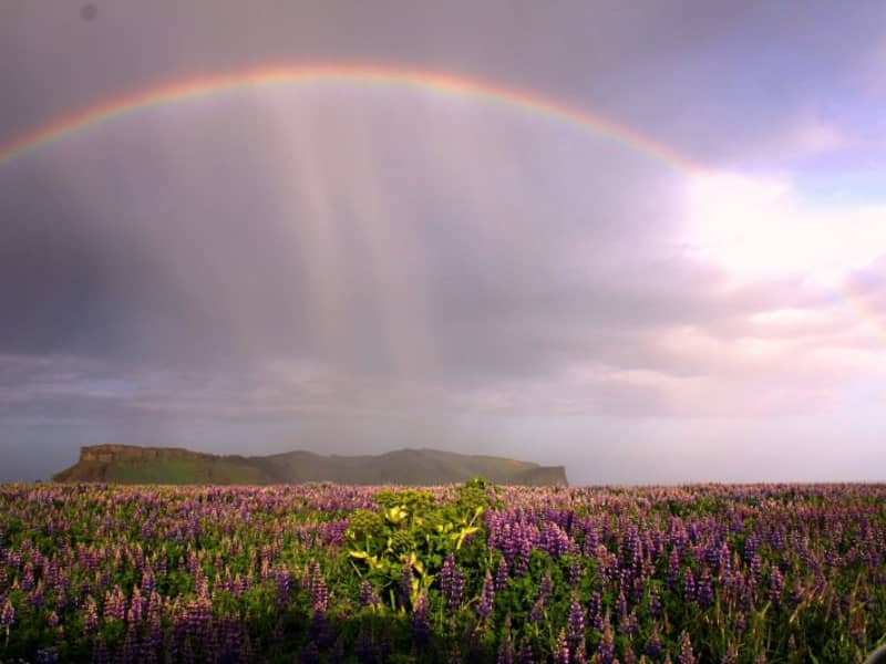
If the sun conditions are favorable - one can see a vivid rainbow in front of the waterfalls. The river below the falls holds a large salmon and char population, and fishermen are seen here fishing from July - October. The path leading to the top of the waterfalls continues following the river upstream - where numerous more dramatic waterfalls of sheer beauty are found. A great hike - to say the least!
One of the finest folk museums in Iceland is situated in extraordinarily beautiful natural surroundings. The fascinating local folk museum has a collection of over 6000 artifacts and examples of various types of dwellings in Iceland since the early times. The collection of tools and equipment used on land and sea is outstanding. The museum also has an old turf farmhouse, where guests can experience the standards of living in Iceland in past centuries.
From Skógar, the Ring Road runs eastwards along the foot of Mýrdalsjökull glacier, across the southern sandy plains and over glacial rivers, passes Seljavellir, and continues along with the soaring glaciated massive of Eyjafjöll and the two waterfalls Seljalandsfoss and Gljúfrabúi. From here runs a 10 km long trek along the river Skógá over the Fimmvörðuháls Pass between the Eyjafjallajökull and Mýrdalsjökull glaciers to the mountain oasis of Þórsmörk.
Skógar is a place to explore the natural diversity of the south or, if the weather is good, to spend a holiday amid beautiful and rugged landscapes. It is also very close to the ocean and the unique black beach.
View
Seljalandsfoss waterfall
A unique waterfall in the river Seljalandsá, about 30 km west of Skógar: it is 60 meters high with a footpath behind it at the bottom of the cliff, but with a thin cascade. It is the only known waterfall of its kind where it is possible to walk behind it. The waterfall is very picturesque; therefore, its photo can be found in many books and calendars.
Access to the waterfall is from the farm of Seljaland along the Ring Road, Iceland's main highway. Several falls a little further to the west, including the interesting Gljúfrabúi, partially masked by its canyon. Access to it is from Hamragarðar farm along the road, east of Markarfljót.
These "do-not-miss" attractions lie very close to the main Ring Road at the base of the Eyjafjallajökull Glacier, on the road leading into Thorsmörk.
During winter, the area around Seljalandsfoss waterfall can be dangerous as paths can be slippery and large pieces of ice fall, making it extremely dangerous to venture too close to the cliffs and particularly dangerous to walk behind the waterfall. The fine mist from the waterfall freezes on the cliffs and the ceiling of the path behind the waterfall, but when the weather warms, and the ice begins to thaw, it can fall off in large chunks, which can be dangerous. People are advised to show caution and respect the closure of the paths. More information can be found on www.safetravel.is
View
Fimmvörðuháls
Fimmvörðuháls is situated in between two glaciers, Eyjafjallajökull and Mýrdalsjökull.The hiking trail over Fimmvörðuháls is one of the most popular one in Iceland and even more so now when hikers can explore the eruption sites up there. The trail starts at Skógar and takes us from the beatiful Skógafoss waterfall along the Skógá river. The distance is about 20 km. with estimated hiking time between 8 - 12 hours. Elevation increases and decrease is 1.000 meters. The route is especially beautiful if you walk from south to north, as there are unusually many streams in Skógá and a beautiful view down to Þórsmörk when you cross the ridge. Be prepared for sudden changes in weather since the trail leads us between two glaciers.
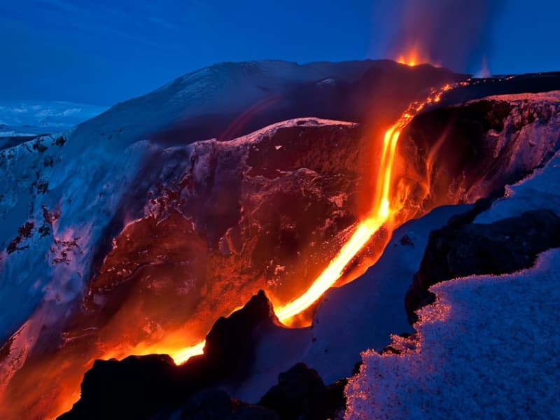
The eruption at Fimmvörðuháls began on the eve of March 21, 2010. Then there were reports of an eruption with associated ash fall in or near Eyjafjallajökull and the information came from the Police in Hvolsvöllur. The eruption was north of Fimmvörðuháls, just east of Eyjafjallajökull. This eruption is classified as a lava eruption. The lava flow from the eruption fissure formed the highest lava waterfall in the world that flows down into a gorge near the eruption fissure. The lava waterfall was about 200 meters high.
View
Gluggafoss waterfall
The Merkjá River has several beautiful waterfalls, but the most outstanding is Gluggafoss or Window Falls(also known as Merkjárfoss). The upper half of the cliff is palagonite or tuff rock, and the lower ledge is basalt. The river has formed tunnels and grooves through the soft rock and a series of ‘windows’ in the tunnels, thereby earning the name ‘Gluggafoss.’
The river passes under a stone arch at the very top of the falls. As the rock is relatively soft, the waterfall has changed over time. Around 1947 the upper half of the waterfall could hardly be seen as the water flowed into a vertical tunnel behind the cliff. It was only visible through three different openings or ‘windows’ one above the other. The water came out through the bottom ‘window’, forming a beautiful arch, except when the water rose in the river, forcing it through all three windows.
Further changes occurred when Hekla erupted in 1947, causing a 20 cm thick layer of volcanic ash to be carried downstream by the river. The vertical tunnel formation nearly disappeared as it filled with ash. It has taken almost 50 years for the falls to return to their former glory.
More geosites in the neighborhood: www.katlageopark.com
View
Eyjafjallajökull Glacier
The Eyjafjallajökull glacier is a 1651 m high glacier-capped stratovolcano. It is one of the smaller glaciers of Iceland. It is situated to the north of Skógar and to the south and west of the bigger glacier Mýrdalsjökull. The icecap of the glacier covers a volcano (1651m in height) that has erupted relatively frequently since the Ice Age. The crater of the volcano has a diameter of 3-4 km and the glacier covers an area of about 100 km². In June 1994 an earthquake swarm lasting for nearly a month occurred below the active volcano Eyjafjallajökull in South Iceland. It is otherwise a relatively quiet volcano – although it is not listed as being inactive. Eyjafjallajökull erupted in 1821-1823. The south end of the mountain was once part of the Atlantic coastline. As the sea has since retreated some 5 km, the former coastline has left behind sheer cliffs with a multitude of beautiful waterfalls, the best known of them being Skógafoss and Seljalandsfoss. In strong winds, the water of some of the smaller falls can even be blown up the mountain. It is one of the three glaciers that surround the Thorsmörk area - the other 2 being Myrdalsjökull and Tindfjallajökull. Specialized tours are arranged on the glacier for both skiing, super jeep tour, and hiking. One should never venture onto the glacier without guides and good knowledge of this kind of activity as this is a very dangerous area for inexperienced visitors.
Eyjafjallajökull featured prominently in world news in 2010 when ash from its eruption halted air traffic in Europe. An ice cap with several outlet glaciers covers the caldera of Eyjafjallajökull with a crater diameter 3-4 km wide. The outlet glaciers, Steinholtsjökull and Gígjökull, descend from the main glacier and can be visited by 4x4 trucks along the F-road to Þórsmörk. The area between the glaciers Eyjafjallajökull and Mýrdalsjökull with volcanic craters, Magni and Móði, created in the first stage of the Eyjafjallajökull eruption in April 2010.
View

Eldfell
Hiking to the top of the volcano Eldfell is one of the most popular trails on Heimaey. This volcano was created in the eruption in 1973 which lasted for about six months and during that time nearly one-third of all the homes and buildings on Heimaey had burned or been covered under the lava and ash. The volcanic museum, Eldheimar tells the story of the eruption and is very nice to visit prior to hiking up the volcano.
View
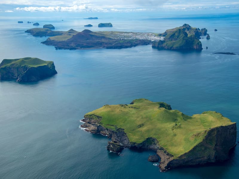
Surtsey Island
Surtsey, on the UNESCO World Heritage list, from July 7, 2008
Surtsey, Iceland’s youngest volcanic island, has been added to the prestigious UNESCO World Heritage list following the World Heritage Committee held in Quebec City on July 7, 2008."Surtur comes from the South... the hot stars down from Heaven are whirled. Fierce grows the steam and the life-feeding flame, until fire leaps high about Heaven itself."- From the Icelandic poem Völuspá, ca. 950 A.D.Surtsey is not only one of the world's newest islands, but the most filmed and researched and one of the most restricted. Ever since the eruption in 1963 which heaved it up out of the waters 18km (11 miles) southwest of Heimaey, its progress has been monitored. This has been giving scientists a fascinating insight into how a new island evolves, how flora and fauna develop, and so on. Because of this very few people are now allowed to visit the island, and special permits are only granted for scientific research.On the 14th of November, 1963 Icelandic seamen, that were fishing about 20 km southwest of Heimaey ( Vestmannaeyjar ) observed the beginnings of an undersea eruption that originated at a 130 meters depth. When the eruption first occurred, columns of ash were sent almost 9,146m (30,000 ft) into the sky and could be seen on clear days as far away as Reykjavík. An island eventually rose to a height of 169 meters above sea level that had an area of 2,5km².This island was named Surtsey for Surtur, the fire possessing giant of Norse mythology who would set fire to the earth at the Last Judgment. Because of pounding seas, there was a considerable amount of early erosion, but the island core quickly solidified as rock and is now holding its own while scientists watch everything.For three and a half years Surtsey rumbled and lava flowed. Long before the eruption stopped the island was proclaimed a nature preserve and all travel there was restricted to scientists that used this unique opportunity to study the gradual development of life on a sterile landmass. The first living found in the ash deposits close to shore. In May of the same year, a fly was found on the island. Seagulls visited the tidewaters furthest from the crater. The first vascular plant to flower along the shore was the sea rocket, observed in 1965. By 1987, twenty-five species of higher plants (including tomatoes!!) had been observed, transported there by seed in the sea currents, some from a nearby island, others from the southern Icelandic coast 40 kilometers off. Other species of plants have been carried there by the winds or birds from Europe.Surtsey is a favorite resting place for migratory birds during seasonal flights to and from Iceland and Europe. They visit there yearly by the thousands. Seals also visit the island and relax on its beaches. Today five species of birds nest on Surtsey: the Herring Gull, the Black-Backed Gull, the Black Guillemot, The Kittiwake, and Fulmar which was the first species to nest there and hatch its young on the warm lava in 1970. BBC and David Attenborough have produced acclaimed television programs from this amazing little island.
View