The Waterfalls of the Geopark
Many beautiful waterfalls are within Katla Geopark and most of them have it in common that they fall off an old sea-cliff line formed at the end of the last glaciation in Iceland when the relative sea level was much higher than it is today. The waterfalls listed here are all close to the ring road (road nr. 1) and are easily accessible for most people. There are also numerous other waterfalls within the Geopark, as are magnificent geosites and museums. The short route lies between the towns of Hvolsvöllur and Vík and the traveling time is about two hours. The longer route goes to the east of the town of Kirkjubæjarklaustur and the traveling time for that route is about four hours. The shorter route is a perfect day tour, while it would be a good idea to stay overnight somewhere if the longer route is taken. There are many hotels, hostels, cabins, and camping sites near the waterfall route, so finding a place to stay should not be difficult.
Gluggafoss waterfallThis beautiful waterfall is about 21 km east of the town of Hvolsvöllur. To get to it you will need to drive through the town to road nr. 261 which will take you all the way to the waterfall. On that road, and indeed at the waterfall, there is a gorgeous view of the surroundings.
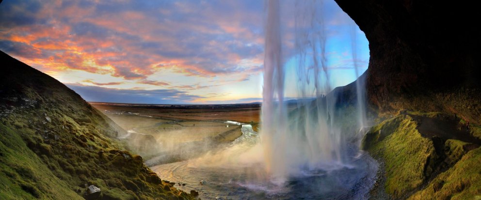
Seljalandsfoss waterfallIs one of the best-known waterfalls in Iceland, and is one of few waterfalls you can walk behind in Iceland. There is another beautiful waterfall nearby, called Gljúfrabúi, which is about 300meters north of Seljalandsfoss. The waterfalls are close to road nr. 1. You will need to turn to road nr.249 to get to the waterfall, and the turnoff is well marked.
Drífandi waterfallIs a waterfall in the Eyjafjöll mountain range. The waterfall is famous for the water in it sometimes not being able to reach the ground, as the water is blown away on the way down due to heavy wind. It is close to road nr. 1, and there is a small parking place near a large weather sign shortly after the turn-off to Seljalandsfoss.
Skógafoss waterfallIs a 62 m high waterfall located at Skógar. It is considered one of the most magnificent waterfalls in Iceland, especially when a rainbow forms in front of it. It is possible to walk almost all the way up to it, but be careful as the water spray can be powerful. To get to the waterfall, you turn off-road nr. 1 to Skógar and follow the signs to the car park.
Kvernufoss waterfallIs in a small canyon 1.5 km to the east of Skógafoss. A hiking path leads up to it from the car park of the museum at Skógar. We recommend checking out the museum along the way, where you can learn about the history of the area and how people traversed the glacial rivers before they were bridged.
Systrafoss waterfallIs in the river Fossá that flows from Systravatn lake near the town of Kirkjubæjarklaustur. The waterfall is in a small canyon just on the edge of the town. To get to the waterfall, you first need to drive into town, and then west on Klausturvegur road to the western part of the town.
Stjórnarfoss waterfallIs a small but very beautiful waterfall about 1 km north of Kirkjubæjarklaustur. It is in the river Stjórn which has origins in Geirlandshraun in the highlands further north. A campsite is close to the waterfall, and it is best to park there and then walk the short distance to the waterfall.
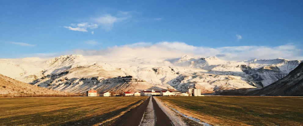
Foss á Síðu waterfallIs about 10 km east of the town of Kirkjubæjarklaustur. The waterfall is behind a collection of farms in a beautiful setting. The water in the waterfall comes from a lake called Þórutjörn. It is possible to walk up to the lake via a small hiking trail near the waterfall and make sure to take in the beautiful views of the surroundings along the way.
Here you can get a printable version of the route.
For more information about the waterfalls, geosites, and available accommodation, please visit www.katlageopark.com
View
Geosites near the Ring road | East side
Geosites near the Ringroad - 1-2 day route
Many famous geosites are within Katla Geopark and everybody should be able to find an interesting site as the variety is high. Within the geopark, there are several central volcanoes, high rising mountains, beautiful waterfalls, moss-covered lava fields, and large black beaches. The geosites listed here are all close to the Ringroad (road nr. 1) and are easily accessible for most people. There are numerous other geosites within the geopark, along with museums, exhibitions, and shows, and we encourage you to have a look at them as well. This route goes from the town of Vík to just east of the town of Kirkjubæjarklaustur. It takes about two hours to drive the route, but with the stops, it is a full-day tour. This route can also be turned into a two-day route by incorporating other routes into it. There are many hotels, hostels, cabins, and camping sites near the route, so finding a place to stay should not be difficult.
Town of VikThere are many things to be done in the town, we recommend the Lava Show and the exhibition at Katla Centre, but if you want more outdoor activity you can go zip lining or horse riding. The beach at Vík is always fun to visit as well, and there is a campground and a swimming pool in the town.
Hjörleifshöfðiis one of the most beautiful tuya (Table Mountain) in Iceland and has a long history. There is a small carpark on the west side, and a nice hiking trail that leads up to the top starts from there. The view from the tuya is great on a sunny day. It is worth checking out a large cave on the south side of the tuya as well.
Laufskálavarða is a lava ridge with hundreds of small kerns and a beautiful view. The small kerns were made by people who were crossing the Mýrdalssandur sandplain for the first time as it was supposed to bring good luck on the journey. The area is protected, so do not build new kerns!
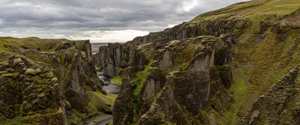
Fjaðrárgljúfur is a canyon with beautiful palagonite formations. The canyon was formed by glacial rivers eroding the rock face at the end of the last glaciation in the area. It is possible to walk along the edge of the canyon and take in the view from above.
Landbrotshólar are rootless cones that formed in an eruption from Eldgjá around the year 939. Rootless cones form when lava flows over wetlands, resulting in high steam pressure that eventually breaks its way through the lava, forming a pile on the surface.
Town of KirkjubæjarklausturThe town is surrounded by natural beauty on all sides, including waterfalls, lava fields and there are plenty of hiking trails available in the vicinity. There is a swimming pool, a campground, and gas stations in the town and we recommend checking out Skaftárstofa info center as well.
Systrastapiis a large rock west of the town of Kirkjubæjarklaustur. A small lake is on top of the mountain next to Kirkjubæjarklaustur and the river Fossá flows from it. The river cascades down the rock face in the middle of the edge of town, forming a beautiful waterfall called Systrafoss.
KirkjugólfKirkjugólf, or church floor, is in a field just north of the town of Kirkjubæjarklaustur. This is about a 60 m2 flat collection of basalt columns that has been glacial and wave eroded. The top of each column is visible, giving a different and fun view of them.
Lómagnúpur is a 767-meter high mountain rising over the lower-lying areas to the east of Kirkjubæjarklaustur. The area is known for its natural beauty as volcanoes, glaciers, and rivers have shaped the landscape there. The area offers great views over glaciers, glacial rivers, black sands, and mountains.
Dverghamrar is a rock face with peculiar, but magnificent-looking, basalt columns. This area, as large parts of the south coast were, was sculpted by glaciers and then by wave erosion at the end of the last glaciation in Iceland.
For more information about the waterfalls, geosites, and available accommodation, please visit www.katlageopark.com
Here you can get a printable version of the route.
View
The Geology Trail | Katla Geopark
Many exciting geological sites are within Katla Geopark and they offer varied geology and often spectacular views. The sites listed here are all close to the ring road (nr. 1) and are easily accessible for most people. There are also numerous other Geosites within the Geopark that offer insight into the geology and geological processes and are listed on the Geopark's webpage. The Geology trail can be split into two parts, the east, and the west. The west trail lies between the towns of Hvolsvöllur and Vík and the traveling time is about two hours. The eastern trail goes to the east of the town of Kirkjubæjarklaustur and it takes also about 2 hours to drive that trail. Each part of the trail is therefore a perfect day tour, while it would be a good idea to stay overnight somewhere if you plan to do both. There are many hotels, hostels, cabins, and camping sites within the Geopark, so finding a place to stay should not be difficult.
Markarfljót and LandeyjasandurMarkarfljót is a glacial river and its delta is known for its power and wildlife. Landeyjarsandur is a spectacular black sand beach. The best way to access it is near the Landeyjarhöfn harbor, and the harbor offers a magnificent view over the Westman islands as well.
Steinahellir caveis a small palagonite cave with a long history. The area around the cave is quite spectacular as well, as the surrounding area is littered with large boulders that have fallen off the steep, nearby mountainside. If you walk a short distance to the east from the car park you can view the boulders better. A small estuary is just south of the cave that is worth a visit as well.
Eyjafjallajökull glacier and volcanoThe glacier is especially beautiful when it has fresh snow covering it and the outline of the caldera can be seen underneath the ice. There is a viewpoint on the right-hand side of the road (if you are driving east) shortly after the stop at Steinahellir cave. The view of Steinafjall mountain is very good from the viewpoint as well, where you can see alternating layers of palagonite and lava.
Sólheimajökull outlet glacierIt is possible to walk towards the glacier for a better view. The glacier has been retreating quickly over the last few decades and an ever-growing glacial lagoon has formed in front of it with a few icebergs in it. The glacial landscape around the glacier is breathtaking and a wide variety of glacial formations can be seen on the plain in front of it.
Pétursey Tuyaor the island of Peter is a small tuya on the south coast. It has beautiful palagonite formations on its side and the view from the top is spectacular. An unmarked hiking path goes from a small car park west of the tuya and to the top.
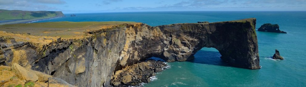
Dyrhólaey IslandThe view from there is absolutely gorgeous and during the summertime, a number of puffins nest there. A car park is on the lower island, called Lágey, and from there it is possible to hike up to the higher island. Palagonite, columnar basalt, and coastal erosion are just a few of the things the site has to offer, and the drive to it from road 1 offers some exciting formations as well.
Reynisfjara, black sand beachis one of the more well-known beaches in Iceland, famous for its black sand. The view from there over the Reynisdrangar sea stacks is very good and there is a beautiful basalt column wall on the side of the nearby mountain, but do not enter the cave as rocks can fall from the ceiling there. The waves on the beach are dangerous, so do not go too close to the sea either!
Reynisfjall mountainis a beautiful palagonite ridge, next to the village of Vík. There is a relatively easy hiking path (road) leading up to the mountain from Vík. The view of Reynisdrangar and Dyrhólaey is otherworldly and palagonite formations and column basalt can be found in many places.
Hjörleifshöfðiis one of the most beautiful tuyas (Table Mountain) in Iceland and has a long history. There is a small car park on the west side, and a nice hiking trail that leads up to the top starts from there. The view from the tuya is great on a sunny day. It is worth checking out a large palagonite cave on the south side of the tuya as well.
Álftaversgígarare rootless cones that formed in an eruption from Eldgjá around the year 939. Rootless cones form when lava flows over wetlands, resulting in high steam pressure that eventually breaks its way through the lava, forming a pile on the surface. The site also offers great views over Mýrdalsjökull glacier, Hafursey tuya, and Mýrdalssandur outwash plain.
Laufskálavarðais a lava ridge with hundreds of small kerns and a beautiful view. The small kerns were made by people who were crossing the Mýrdalssandur sandplain for the first time as it was supposed to bring good luck on the journey. The area is protected, so do not build new kerns or add to the existing ones!
Skaftáreldahraun lava fieldis the second-largest lava field formed in the last 1100 years and was formed during the Laki eruption in 1783-84. Most of the lava is covered by moss, giving it a smoother look and a nice color contrast. There is a nice viewing platform at the site, offering great views over the surrounding area.
Fjaðrárgljúfuris a canyon with beautiful palagonite formations. The canyon was formed by glacial rivers eroding the rock face at the end of the last glaciation in the area. it is possible to walk along the edge of the canyon and take in the view from above.
Landbrotshólarare also rootless cones that formed in an eruption from Eldgjá around the year 939. In this area, the cones are more vegetated and some are more accessible. Skaftá, the nearby glacial river flows close by, and during the summertime you can see a cross-section of an old wall near Hotel Laki, revealing numerous tephra layers.
Systravatnis a small lake on top of the mountain above the town of Kirkjubæjarklaustur. The river Fossá flows from the lake and cascades down the rock face forming a beautiful waterfall called Systrafoss. Near the lake are beautiful formations, old lake coastlines, and a perfect view of the surroundings, including the Skaftá river and its black sands.
Dverghamraris a rock face with peculiar, but magnificent-looking, basalt columns. This area, as large parts of the south coast were, was sculpted by glaciers and then by wave erosion at the end of the last glaciation in Iceland. Block lava sits on top of the columns, forming a nice contrast. Nearby, there is a site called Orustuhóll and it is worth going there as well. In both locations, beautiful palagonite formations can be seen on top of the nearby mountain.
For more information about the waterfalls, Geosites, hiking maps, and available accommodation, please visit www.Katlageopark.com.
Here you can get a printable version of the route.
View
Geosites near the Ring road | West side
Geosites near the Ringroad - 1-2 day route
Many famous geosites are within Katla Geopark and everybody should be able to find an interesting site as the variety is high. Within the Geopark, there are several central volcanoes, high rising mountains, beautiful waterfalls, moss-covered lava fields, and large black beaches. The geosites listed here are all close to the Ringroad (road nr. 1) and are easily accessible for most people. There are numerous other geosites within the geopark, along with museums, exhibitions, and shows, and we encourage you to have a look at them as well. This route goes between the towns of Hvolsvöllur and Vik. It takes about two hours to drive the route, but with the stops, it is a full-day tour. This route can also be turned into a two-day route by incorporating other routes into it. There are many hotels, hostels, cabins, and camping sites near the route, so finding a place to stay should not be difficult. For more information about the waterfalls, geosites, and available accommodation, please visit www.Katlageopark.com.
Town of HvolsvöllurThere are many things to be done in the town, we recommend checking out the Lava Centre and Saga trail exhibitions, as well as one of the several restaurants in town. There are also a couple of hiking trails nearby, along with a swimming pool and gas stations.
Seljalandsfoss waterfall is one of the best-known waterfalls in Iceland and the only one you can safely walk behind. There is another beautiful waterfall nearby, called Gljúfrárbúi, and is about 300 meters north of Seljalandsfoss. The waterfalls are close to road nr. 1. and the turn to the waterfalls is well marked.
Steinahellir cave is a small palagonite cave with a long history. A small carpark is in front of it along with information signs about its history. The area around the cave is quite spectacular as well, as the surrounding area is littered with large boulders that have fallen off the steep, nearby the mountainside.
Eyjafjallajökull glacier and volcanoThe glacier is especially beautiful when it has fresh snow covering it and the outline of the caldera can be seen underneath the ice. There is a viewpoint on the right-hand side of the road (if you are driving east) shortly after the stop at Steinahellir cave.
Rútshellir cave is another palagonite cave but has an old sheep shed in front of it as well. It is possible to go in there and have a look around. A similar rock formation is nearby called Drangurinn, where you can see a few more old sheep sheds and small barns built next to the rock.
Skógafoss and Skógar museumThe waterfall is one of the most beautiful waterfalls in Iceland with a short hiking trail leading up the side, giving a chance to have a look at it from above. The nearby Skogar museum is worth a visit as well and there is a small restaurant there that is perfect for lunch.
Sólheimajökull outlet glacierIt is possible to walk towards the glacier for a better view and to go on guided trips onto the glacier. The glacier has been retreating quickly over the last few decades and a small glacial lagoon has formed in front of it with a few icebergs in it.
Dyrhólaey islandThe view from there is absolutely gorgeous and during the summertime, a number of puffins nest there. A carpark is on the lower island, called Lágey, and from there it is possible to hike up to the higher island.
Reynisfjara, a black sand beach is one of the more well-known beaches in Iceland, famous for its black sand. The view from there over the Reynisdrangar sea stacks is very good and there is pillow basalt on the side of the nearby mountain, but do not enter the cave as rocks can fall from the ceiling there. The waves on the beach are dangerous, so do not go too close to the sea either!
Town of VikThere are many things to be done in the town, we recommend the Lava Show and the exhibition at Katla Centre, but if you want more outdoor activity you can go zip lining or horse riding. The beach at Vík is always fun to visit as well, and there is a campground, a swimming pool, and gas stations in the town.
Here you can get a printable version of the route.
View