Volcanoes vary greatly depending on the type of magma which emerges, how the magma reaches the surface and on how much magma reaches the surface. Iceland has a great diversity of volcanoes. There are eruptions under glaciers, in the sea, effusive eruptions, and explosive eruptions of varying size and type. Eruptions can also change mid-eruption, e.g. from tephra eruptions or explosive eruptions to effusive eruptions. This happened during the Surtsey eruption for example, which began as a powerful submarine tephra eruption and eventually, as an island was formed around the vent, lava began to flow, to the delight of geologists and others as it reinforced the island against the erosive forces of the sea. Several other islands appeared in the same eruption but have all since disappeared.
Main types of volcanoes
Volcanoes vary greatly depending on the type of magma which emerges, how the magma reaches the surface and on how much magma reaches the surface. Iceland has a great diversity of volcanoes. There are eruptions under glaciers, in the sea, effusive eruptions, and explosive eruptions of varying size and type. Eruptions can also change mid-eruption, e.g. from tephra eruptions or explosive eruptions to effusive eruptions. This happened during the Surtsey eruption for example, which began as a powerful submarine tephra eruption and eventually, as an island was formed around the vent, lava began to flow, to the delight of geologists and others as it reinforced the island against the erosive forces of the sea. Several other islands appeared in the same eruption but have all since disappeared.
Shield volcanoes
Shield volcanoes reached peak activity at the end of the last Ice Age, 10-12,000 years ago. After the weight of the ice caps had disappeared the land rose again. Volcanic eruptions became more frequent and huge effusive eruptions occurred away from the central volcanoes. Magma appears to have come all the way from the mantle as there is no magma chamber beneath the shield volcanoes. The fissures were initially long but as eruptions continued the centre of activity became concentrated in one crater and finally formed a shield volcano. The largest such shield volcano in Iceland is Skjaldbreið and the eruption which formed the mountain probably lasted decades. Eruptions of this type decreased sharply in number once uplift had slowed down and more typical volcanic activity began to take over.
Effusive eruptions
An effusive eruption is a type of eruption in which the majority of volcanic material is in the form of lava. The most common effusive eruptions are basaltic eruptions, and lava can be classified as vicious, slow-flowing lava known by the Hawaiian term a’a, or thin, smooth lava known by the term pāhoehoe. The Skaftáeldar (Skaftá Fires) eruption is an example of an effusive eruption.
Explosive eruptions and Plinian eruptions
Strictly speaking, these terms refer to the same phenomenon. Explosive eruptions occur when magma comes into contact with water, either high up in the crust (groundwater) or at the surface. Another critical factor is how fast the magma is forced up the conduit. Eruptions beneath glaciers or the sea are most likely to become explosive eruptions but this is not always the case. The eruption at Askja in 1875 is an example of a very powerful explosive eruption.
Subglacial eruptions
Many central volcanoes in Iceland are covered by ice. In Southern Iceland, these volcanoes include Katla, Eyjafjallajökull, Bárðarbunga and Grímsvötn. When volcanoes erupt beneath glaciers the material ejected is in the form of tephra or ash in tephra eruptions (phreatomagmatic eruptions) or explosive eruptions.
Glacial outbursts
Subglacial volcanoes are dangerous due to the sometimes massive ashfall and also because of glacial outbursts or jökulhlaup which occur when eruptions cause glacial ice to melt. Vast tracts of land in Southern Iceland are uninhabitable due to regular glacial outbursts. The great sands around Mýrdalsjökull and Vatnajökull have been formed by glacial outbursts, mainly from Katla (Mýrdalssandur) and Grímsvötn (Skeiðarársandur).
Submarine eruptions
The area around the Reykjanes peninsula has been a hotspot for volcanic activity throughout the ages. The Surtsey eruption from 1963 to 1967 is one of the most famous submarine volcanoes. The location surprised scientists as the Vestmannaeyjar system had been considered dormant until the eruption. A further eruption occurred on the island of Heimaey in 1973. Submarine eruptions resemble subglacial eruptions in that the main volcanic material produced is tephra. If the eruption forms an island, lava can flow, as was the case on Surtsey. Submarine eruptions have seldom caused any damage in Iceland. They are rarely large and not all of them reach the surface and are sometimes only detected by scientific instruments.
View
Volcanoes in South Iceland
Hengill
The Hengill volcanic system is around 60 km long and has been relatively active, having erupted 9 times in the Holocene. The Hengill system is located where the West Volcanic Zone and the South Iceland Seismic Zone meet. The area is characterized by faults formed during series of eruptions. Hengill is home to Iceland’s second-largest geothermal area.
Grímsnes
The Grímsnes volcanic system is located at the eastern edge of the West Volcanic Zone and has not been active for 7,000 years. It is 12 km in length and up to 5 km wide, making it one of the smallest and least active volcanic systems in Iceland. It contains 12 minor eruption sites which have produced a small amount of basaltic lava and tephra.
Langjökull – Prestahnúkur
The Prestahnúkur volcanic system has been relatively active and has erupted six times in the Holocene, most recently around the year 900. The system is located at the western edge of the West Volcanic Zone. It is around 90 km long and 15 km wide and contains a central volcano characterized by rhyolite. The area is geothermally active and has fissure swarms with conspicuous faults. The volcano is covered in parts by 300 metre thick ice.
Hekla
Hekla is one of the most active and famous volcanoes in the world. In the Middle Ages, it was rumoured to be the gateway to hell. The Hekla volcanic system has been highly active in the Holocene. It last erupted in 2000 and has erupted 23 times in the last 1,000 years, making it the third most active volcanic system in Iceland.
The length of the preceding period of dormancy determines the silica content of the first magma to reach the surface and the volume of the volcanic material, meaning that the shorter the period of dormancy, the smaller the eruption. Eruptions in Hekla can range from pure explosive eruptions to pure effusive eruptions.
The Hekla volcanic system is located in the East Volcanic Zone. The fissure swarm is approximately 60 km in length and the volcano reaches a height of 1490 m above sea level. Eruptions are most frequent in the central volcano and are generally a mix of tephra and lava eruptions. The initial phase of Hekla eruptions tends to be short, with an explosive eruption followed by lava flows.
Vestmannaeyjar
Activity in the Vestmannaeyjar has been limited in the Holocene. There was a series of eruptions from 1963 to 1973, first around Surtsey (1963-67) and then at Heimaey in 1973. The system is 30-35 km in length and 20-25 km wide and forms an archipelago 10-30 km off the south coast of Iceland, whose highest point is Heimaklettur at 283 m. The most recent eruption before the last series of eruptions was believed to have been at Helgafell, 5,900 years ago. The archipelago comprises 15 islands and 30 skerries which are the remains of craters and islands formed during the Holocene.
The Heimaey eruption
The Heimaey eruption was a fissure eruption that opened up at the edge of the town and then became concentrated in a single crater, Eldfell. Almost the entire population of the town, around 5,000 people, was evacuated to the mainland on the night the eruption began. Around 400 houses were buried under tephra and lava. The eruption lasted for almost five and half months. Only one person died in the eruption, a victim of poisonous gases in the basement of a house. There was some concern that the lava would close off the harbour, but in fact, it improved it, providing more shelter. Hot lava was used to heat houses in the town for around 15 years after the eruption ended, probably the only case of lava-heated homes in the world.
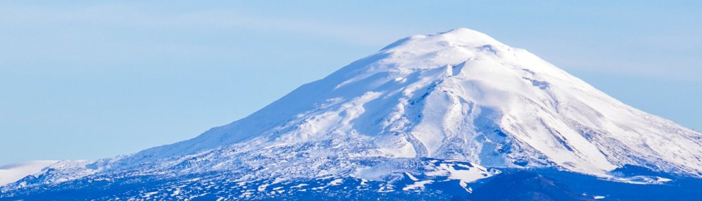
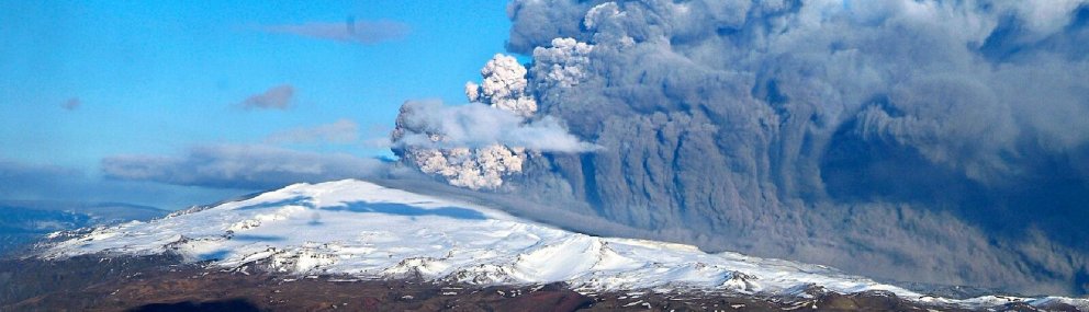
Eyjafjallajökull
The central volcano Eyjafjallajökull has been relatively active over the last 8,000 years. The last eruption occurred in 2010 when 0.27 km3 of tephra and 0.023 km3 of lava was ejected. Eyjafjallajökull is 1651 m high and is located in the East Volcanic Zone and the central volcano is considered to be an independent volcanic system. The summit contains a 2.5 km wide ice-filled caldera. The upper part of the volcano is largely covered by a glacier that is up to 200 metres thick.
The ash plume from the 2010 eruption consisted of such fine ash that it posed a major threat to jet engines. As a result flight routes and airports across much of Europe were closed for a week in mid-April. Routes from Keflavík to North America did remain open but they nevertheless represented the most wide-reaching restrictions on global flights since the Second World War.
Torfajökull
The Torfajökull area has been fairly active in the Holocene. The last eruption was in 1477 along a 40 km long volcanic fissure northeast of Landmannalaugar. This eruption created such well-known geographical features as Veiðivötn, Laugahraun, Námshraun, Norðurnámshraun, Ljótipollur and much of the pumice sand covering the northern part of the Fjallabak Nature Reserve. Torfajökull is in the East Volcanic Zone.
The area saw a high level of volcanic activity during the last glacial period, creating the tuff peaks Löðmundur and Mógilshöfðar, and the rhyolite mountains Bláhnúkur, Brennisteinsalda and Kirkjufell. Rhyolite from the last interglacial period can be found at Norður-Barmur and Brandsgil. The Fjallabak Nature Reserve is home to numerous well-known geothermal areas, such as Landmannalaugar, Hrafntinnusker, Kaldaklof, Jökultungur and Reykjadalir.
Katla
The Katla volcanic system, which is partly covered by Mýrdalsjökull, has been highly active in the Holocene and the past 11 centuries have seen at least 21 eruptions. The last eruption to break through the ice cap was in 1918 and it was considered a major eruption. People have been waiting for an eruption in Katla for some time; there have been some minor eruptions but they have not penetrated the ice.
Katla is a major central volcano, one of the largest and most active in the country. It is about 30 km in diameter and reaches a height of 1480 m. In the centre of the volcano is the Katla caldera which covers an area of 100 km2 and is up to 700 metres deep. The ice in the caldera is in many places 400-700 m thick. The caldera is divided into three drainage areas: Kötlujökull, Sólheimajökull and Entujökull.
Bárðarbunga
The Bárðarbunga system has been highly active in the Holocene and there have been at least 26 eruptions in the past 11 centuries. The most recent eruption was a large fissure eruption (volume of lava >1.5 km3) in the Holuhraun area north of Vatnajökull which lasted from August 2014 to February 2015. Several smaller eruptions beneath the ice may have occurred before the main eruption.
Grímsvötn
The Grímsvötn volcanic system has erupted more frequently than any other volcanic system in Iceland in the Holocene. The system comprises a central volcano and a fissure swarm which is around 100 km long and up to 20 km across. The highest point is Grímsfjall at 1722 m. The most recent eruption was in 2011 which produced approximately 0.8 km3 of tephra. The Grímsvötn system is part of the East Volcanic Zone and much of it lies beneath the thick ice of Vatnajökull. The Grímsvötn caldera is mostly covered by the glacier. Another central volcano in the Grímsvötn system is Þórðarhyrna to the south-west. This has seen little recent activity, erupting most recently in 1903.
Öræfajökull
Öræfajökull has been relatively active in the Holocene. The most recent eruption was a medium-sized explosive eruption in 1727. Öræfajökull is located outside the main volcanic zones and is one of the few volcanic systems which does not have a fissure swarm, only a central volcano. The central volcano is 20 km in diameter and reaches a peak of 2110 m at Hvannadalshnjúkur, which is also Iceland’s highest mountain. The volcano is covered with ice.
Hrómundartindur, Hofsjökull, Tindafjallajökull and Esjufjöll are volcanoes in Southern Iceland which have only seen limited eruptions in the Holocene.
View
Major eruptions outside or on the edge of central volcanoes
Þjórsárhraun
The great lava expanse of Þjórsárhraun is the largest lava field in Iceland, both in terms of area and volume, and is the largest known lava flow on Earth from a single eruption since the end of the last ice age around 10,000 years ago. The lava ran between Hekla and Búrfell and through the lowlands along the course of the river Þjórsá and flowed 1 km out to sea at Eyrar. The lava is pāhoehoe and originated from volcanoes in the Veiðivötn area around 8,600 years ago. This eruption was presumably part of the Torfajökull volcanic system.
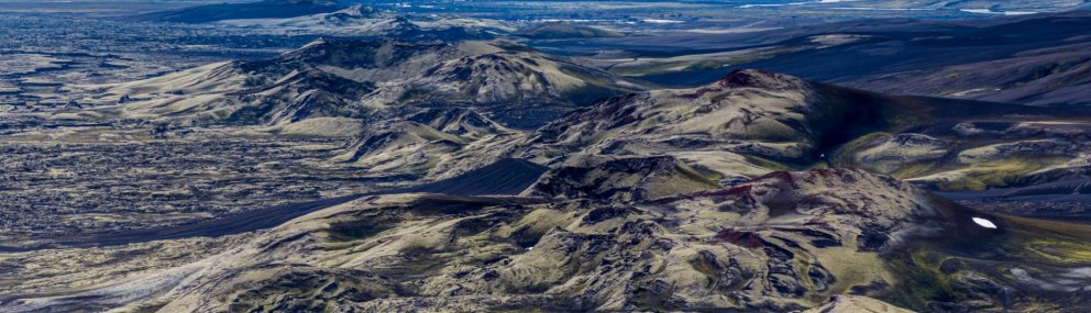
Vatnaöldur 870
Just as the first settlers were thought to have been arriving in Iceland, a major eruption was coming to an end at Vatnaöldur in the Fjallabak area. A fissure at least 10 km long opened and ejected 3.3 km3 of tephra and a small amount of lava. This eruption and a simultaneous eruption in the Torfajökull system produced what is known as the “settlement layer,” a bicoloured layer of tephra. This layer of ash is often referred to when scientists need to date archaeological remains in the ground. Major eruptions in the Veiðivötn area often appear to have accompanied unrest in the Torfajökull system. The eruption produced substantial ash fall across Iceland, except the West Fjords.
Eldgjá 934 – 940
Iceland certainly didn’t give its first settlers a warm welcome. Only 65 years after the huge eruption at Vatnaöldur came to an end, the largest eruption since settlement began at Katla and Eldgjá. This eruption produced massive glacial outbursts and the volcanic fissure grew in both directions for weeks and months. It stretched under the Katla caldera and produced a huge volume of tephra in a cataclysmic eruption. The fissure then extended to the north and created the canyon Eldgjá. The northernmost part of Eldgjá is around 60 km from the glacier which speaks volumes about the scale of the eruption, even though the eruption did not occur along its entire length at the same time.
An enormous amount of lava flowed out of Eldgjá and reached all the way to the sea at Álftaver. Recent studies indicate that the lava from Eldgjá has a volume of 18 km3 and covers an area of 800 km2, making it larger than the Skaftáeldar eruption. Lava from the latter eruption actually flowed over part of the Eldgjá lava. It is thought that the tephra from the eruption has a volume of 5-7 km3 and this amount, irrespective of the lava, is sufficient to classify it as a major eruption. The tephra layer from the Eldgjá eruption is also used to date archaeological finds and is about 65-70 years younger than the settlement layer.
The Eldgjá lava created two well-known pseudocrater clusters, Álftaversgígar and Landsbrotshólar. Álftaversgígar are protected pseudocraters and Landbrotshólar is the most extensive area of pseudocraters in Iceland, covering an area of 50 km2. Pseudocraters are formed when lava flows into or over rivers, lakes or marshes. When 1100°C hot lava comes into contact with water it causes huge explosions as the water vaporizes immediately. This rips apart the lava, hurling tephra into the air and forming hummocks and pseudocraters. Pseudocraters are found in many parts of Iceland, a particularly well-known cluster being at Mývatn. The rock formations Rauðhólar near Reykjavík are the remains of pseudocraters.
Skaftáreldar – Lakagígar
The Skaftáreldar eruption (“Skaftá Fires”) began on Whitsunday, 8 June 1783, in a 27 km long fissure which eventually became the craters known as Lakagígar, and lasted until February 1784. Skaftáreldar produced the largest flow of lava from a single eruption in the last one thousand years, spewing out a total volume of 12-14 km³ and covering an area of 580 km². However, the eruption at Eldgjá might in fact rank ahead of Skaftáreldar as the largest eruption in historical times. Lakagígar form part of the Grímsvötn volcanic system.
The eruption also produced a great amount of ash and poisonous gases which enveloped the country. A thick volcanic haze, rich in sulfurous gases, filled the atmosphere and its effects could be felt throughout the northern hemisphere. The following winter was harsh across Europe, and it is believed that famine in France following the eruption in Iceland may have precipitated the French Revolution. The winter was particularly severe in Iceland. Livestock died and famine raged across the country. The period of hardships following the Skaftáreldar eruption is known in Iceland as móðuharðindin or the famine of the mists, named after the volcanic haze. It lasted until 1785, by which time an estimated 80% of sheep had died, 60% of horses and 50% of cattle. More than 10,000 people in Iceland died in this disaster, more than 20% of the population of Iceland.
View
South Iceland earthquakes
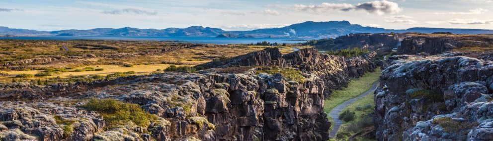
Earthquakes measuring 6 or above on the Richter scale are frequent in Southern Iceland. They occur due to fault movements in a narrow belt stretching east from Ölfus to Hekla. This fault separates the North American Plate to the north from the Eurasian Plate to the south and spreads about 1.8 cm a year. The earthquakes are caused by horizontal movements along faults in a north-south direction and extend through the entire crust, up to 10 kilometres below the surface.
The last major earthquake in Southern Iceland occurred on 28 May 2008 along a fault stretching south from Hveragerði to Eyrarbakki. It measured 6.3 on the Richter scale. In June 2000 there were two earthquakes four days apart, measuring 6.5 and 6.6. These were the first large earthquakes in Southern Iceland since 1912 when an earthquake measuring 7 shook the area. Prior to that, there were 5 quakes in 1896 measuring 6.5-6.9. The Richter scale is a logarithmic scale, meaning that an earthquake measuring 7 is 10 times more powerful than one that measures 6 and 100 times more powerful than one that measures 5. It hardly needs to be said that these earthquakes all caused damage. The earliest recorded earthquake in Southern Iceland was in 1013.
View