Stunning nature reserves to enjoy in South Iceland.
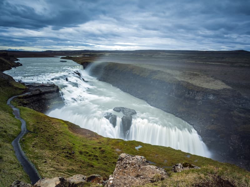
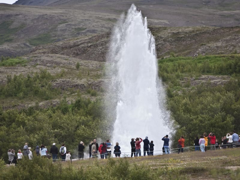
Gullfoss waterfall
Gullfoss is two separate waterfalls; the upper one has a drop of 11 meters and the lower one 21 meters. The rock of the river bed was formed during an interglacial period.
Water flows over Gullfoss at an average rate of 109 cubic meters per second. The heaviest floods have recorded a flow of 2000 cubic meters per second. During the summer, the flow is 130 cubic meters per second, which would take only 3 seconds to fill this building. People were eager to exploit the power potential of Gullfoss, and many plans for hydroelectric developments on the river Hvítá have been proposed.
The trails by Gullfoss can be closed, so it's good to check the conditions before going. To check whether it is open or closed to visitors, check out the website of Safetravel.is.
View
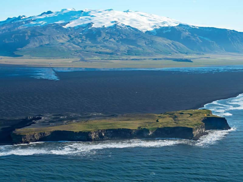
Ingólfshöfði
At the edge of the Atlantic Ocean, Ingólfshöfði is a headland isolated by black sands and perilous rivers from the rest of the mainland.
This historical cape is named after the first settler of Iceland, Ingólfur Arnarson, who spent his first winter there with his family after moving to Iceland, 874-875 A.D.
However, it´s home to thousands of nesting seabirds and gulls, especially puffins and the great skua. Ingólfshöfði is only accessible by organized tours.
View
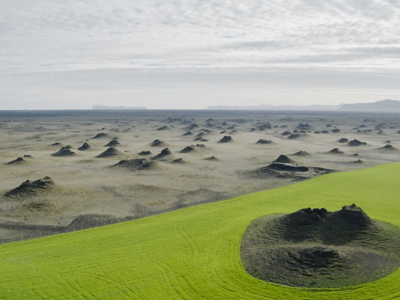
Álftaversgígar
Álftaversgígar is a protected natural phenomenon of international geological significance. An area of rootless cones (pseudocraters) formed by the Eldgjá lava flowing over wetlands in 934-940. A side road south of ring road no.1 takes you to a panoramic spot with information panels.
There is an easy hike along the signed sand track to Dýralækjasker geosite, a former shelter for travelers crossing the sands of Mýrdalssandur on foot or horseback before the time of automobiles. Another excellent place to experience these cones is in a farmed area at Þykkvabæjarklaustur.
View
Hellarnir að Hellum
At Hellar, there are three caves from which the town gets its name. These caves are man-made, carved in sandstone, and one of them is the longest man-made cave in Iceland. It is not known exactly how old these caves are, but it is believed that they are possibly from before the actual settlement of Iceland and were made by the Popes, i.e., Irish monks who settled in this country before the time of the Vikings (about 900).On the other hand, it can be said with full certainty that the caves are at least as old as the town name Hellar, as it is very unlikely to name this town if there were no caves in the area. The first written sources about the farm Hella in Landsveit are from 1332; the caves are at least 600 years old, although they may be even older.
The area is a protected natural site.
View
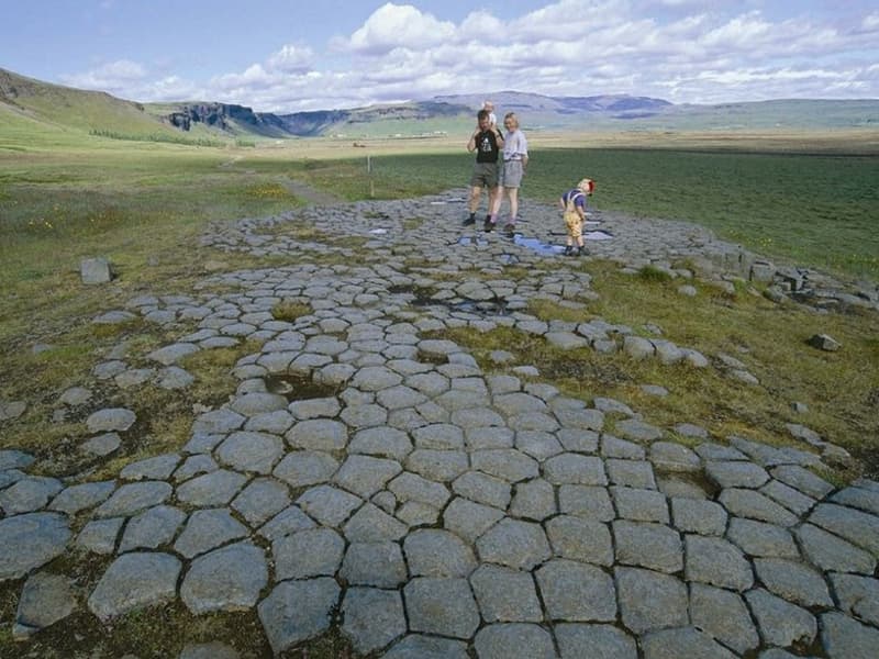
Kirkjugólf
Kirkjugólf, or ‘the church floor,’ is an 80 square meter expanse of columnar basalt stone slabs that slowly eroded when the sea covered the area. The hexagonal ‘tiles’ look like man-made flooring, but there has never been a church or any other building on the site.
The protected natural monument is located just a few hundred meters east of the village of Kirkjubæjarklaustur.
View
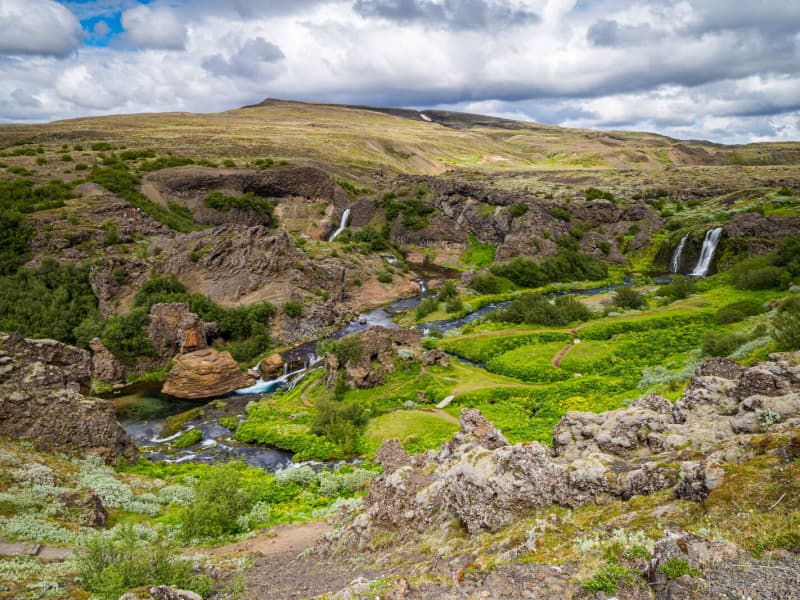
Gjáin in Þjórsárdalur valley
This beautiful natural phenomenon and oasis at the edge of the central highlands should not be passed by if you are traveling in the Thjorsar Valley. The Red River (Rauda) cascades into and through this gorge, and the surroundings are amply vegetated. River Thjorsa ran through before a dike was built between the mountains Sandafell and Skeljafell to redirect it.
One of the younger Tungnaa-Lavas ran down the gorge, leaving a thin layer on its bottom and walls and a thicker layer on the edges. The lava formations are worth taking a closer look at. An easy 10 minutes walk takes you into this beautiful area from the archaeological excavations at Stong, and another approach is from the car track on edge.
Some find this place so beautiful they (secretly) have strewn their ashes in the river to be forever united with monumental nature in this "paradise on earth."
View
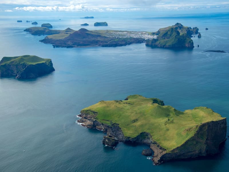
Surtsey Island
Surtsey, on the UNESCO World Heritage list, from July 7, 2008
Surtsey, Iceland’s youngest volcanic island, has been added to the prestigious UNESCO World Heritage list following the World Heritage Committee held in Quebec City on July 7, 2008."Surtur comes from the South... the hot stars down from Heaven are whirled. Fierce grows the steam and the life-feeding flame, until fire leaps high about Heaven itself."- From the Icelandic poem Völuspá, ca. 950 A.D.Surtsey is not only one of the world's newest islands, but the most filmed and researched and one of the most restricted. Ever since the eruption in 1963 which heaved it up out of the waters 18km (11 miles) southwest of Heimaey, its progress has been monitored. This has been giving scientists a fascinating insight into how a new island evolves, how flora and fauna develop, and so on. Because of this very few people are now allowed to visit the island, and special permits are only granted for scientific research.On the 14th of November, 1963 Icelandic seamen, that were fishing about 20 km southwest of Heimaey ( Vestmannaeyjar ) observed the beginnings of an undersea eruption that originated at a 130 meters depth. When the eruption first occurred, columns of ash were sent almost 9,146m (30,000 ft) into the sky and could be seen on clear days as far away as Reykjavík. An island eventually rose to a height of 169 meters above sea level that had an area of 2,5km².This island was named Surtsey for Surtur, the fire possessing giant of Norse mythology who would set fire to the earth at the Last Judgment. Because of pounding seas, there was a considerable amount of early erosion, but the island core quickly solidified as rock and is now holding its own while scientists watch everything.For three and a half years Surtsey rumbled and lava flowed. Long before the eruption stopped the island was proclaimed a nature preserve and all travel there was restricted to scientists that used this unique opportunity to study the gradual development of life on a sterile landmass. The first living found in the ash deposits close to shore. In May of the same year, a fly was found on the island. Seagulls visited the tidewaters furthest from the crater. The first vascular plant to flower along the shore was the sea rocket, observed in 1965. By 1987, twenty-five species of higher plants (including tomatoes!!) had been observed, transported there by seed in the sea currents, some from a nearby island, others from the southern Icelandic coast 40 kilometers off. Other species of plants have been carried there by the winds or birds from Europe.Surtsey is a favorite resting place for migratory birds during seasonal flights to and from Iceland and Europe. They visit there yearly by the thousands. Seals also visit the island and relax on its beaches. Today five species of birds nest on Surtsey: the Herring Gull, the Black-Backed Gull, the Black Guillemot, The Kittiwake, and Fulmar which was the first species to nest there and hatch its young on the warm lava in 1970. BBC and David Attenborough have produced acclaimed television programs from this amazing little island.
View
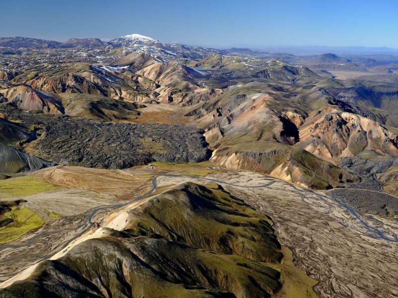
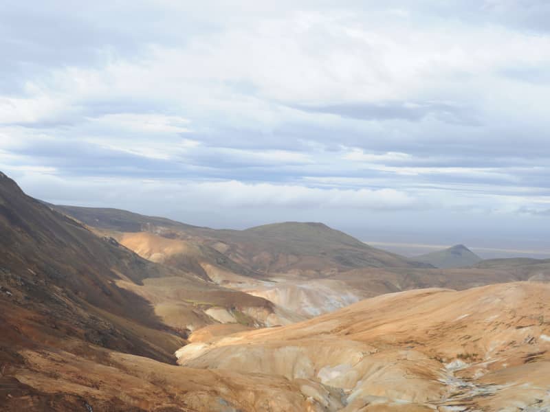
Fjallabak Nature Reserve
Fjallabak Nature Reserve was protected in 1979. The protection aims to preserve unique areas so that future generations have the opportunity to enjoy them in the same way as we do. For this to happen, there are specific rules of conduct to prevent damage to the environment or disruption of the landscape. A diverse landscape, a unique but fragile ecosystem, desert wilderness, and peacefulness are the main characteristics of the Friðland Nature Reserve, and thousands of people visit every year to enjoy the natural resources. Visitors to the area are asked to respect the nature reserve's rules of conduct and thus contribute so that the aim of the protection can be achieved and that everyone, as well as our descendants, can fully enjoy the nature reserve's nature.
The nature reserve is 44,633.4 ha in size and all more than 500 m above sea level. The area is mountainous and shaped by volcanic activity and geothermal heat. The color palette is broad, mostly due to rhyolite and obsidian in the mountains. Lava fields, rivers, and lakes are also prominent in the landscape.
Management and Protection PlanWork on preparing a management and protection plan for the nature reserve is ongoing, and all information about that work can be accessed here in Icelandic.
AccessThe northern Fjallabaksleið route (F208) lies between Land and Skaftártunga, through the Fjallabak Nature Reserve. The Landmannaleið route (F225) lies from road 26 towards Landsmannahellir through Dómadalur and connects to road 208 by Frostastaðavatn. The Sígölduleið route (208) lies from Sprengisandsvegur (F26) to Landmannalaugar.
The land here is especially sensitive to damage from traffic, and as a result, drivers are asked to familiarise themselves with road conditions before embarking on a journey through the nature reserve and not drive outside those roads shown on the map.
Weather ConditionsThe average annual temperature in Fjallabak is probably 0–1°C. July is the warmest month of the year, with an average temperature of 7–8°C. The average temperature of the coldest months, January and February, is around -6°C. Remember that each month's average temperature varies greatly from year to year. Winter conditions and frost can occur at any time of the year. The annual precipitation at Torfajökull glacier, in the southeast corner of the nature reserve, is probably around 2–3 thousand mm but decreases rapidly to the north and northwest and is perhaps down to approx. one thousand mm in the northernmost part of the nature reserve.
Further information about The Fjallabak Nature reserve
View
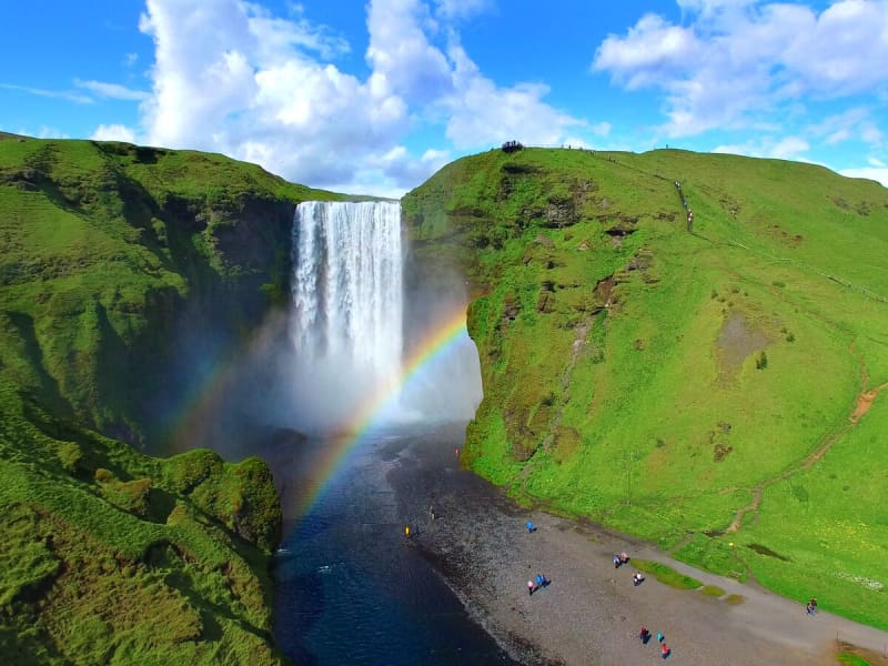
Skógafoss - Waterfall
Only a few kilometers away from the south shores of Iceland lies the village of Skógar along the Southern Ring Road. It is a popular summer resort center surrounded by unusual scenic beauty. The breathtaking view of Skogáfoss waterfall and picturesque surroundings and the snow-capped heights of two towering glaciers are Skógar's major summer attractions. There are two settlements by this name. One is Ytri-Skógar (outer or western Skógar) and the other Eystri-Skógar (eastern Skógar), located at a short distance from each other. Ytri-Skógar, commonly referred to as Skógar, is the main settlement. It is an old farm and has a church from 1890. It is located between the Skógá and Kverná rivers.
The greatest attraction of Skógar is, of course, the beautiful 60-meter high Skogáfoss waterfall in the river Skógá. Like the legends of buried treasures of Egill Skallagrímsson in Mosfell near Reykjavík and Ketilbjörn in Mosfell near Skálholt, there is a similar legend about the settler Þrasi who is believed to have buried his chest of gold under the Skogáfoss waterfall.
If the sun conditions are favorable - one can see a vivid rainbow in front of the waterfalls. The river below the falls holds a large salmon and char population, and fishermen are seen here fishing from July - October. The path leading to the top of the waterfalls continues following the river upstream - where numerous more dramatic waterfalls of sheer beauty are found. A great hike - to say the least!
One of the finest folk museums in Iceland is situated in extraordinarily beautiful natural surroundings. The fascinating local folk museum has a collection of over 6000 artifacts and examples of various types of dwellings in Iceland since the early times. The collection of tools and equipment used on land and sea is outstanding. The museum also has an old turf farmhouse, where guests can experience the standards of living in Iceland in past centuries.
From Skógar, the Ring Road runs eastwards along the foot of Mýrdalsjökull glacier, across the southern sandy plains and over glacial rivers, passes Seljavellir, and continues along with the soaring glaciated massive of Eyjafjöll and the two waterfalls Seljalandsfoss and Gljúfrabúi. From here runs a 10 km long trek along the river Skógá over the Fimmvörðuháls Pass between the Eyjafjallajökull and Mýrdalsjökull glaciers to the mountain oasis of Þórsmörk.
Skógar is a place to explore the natural diversity of the south or, if the weather is good, to spend a holiday amid beautiful and rugged landscapes. It is also very close to the ocean and the unique black beach.
View
Vatnajökull National Park
Vatnajökull National Park was established in 2008. It includes the national parks in Skaftafell (est. 1967) and Jökulsárgljúfur (est. 1973) along with the Vatnajökull ice cap itself and extensive areas around it. Today Vatnajökull National Park area covers 15% of Iceland.
A map showing the park’s boundaries (last updated September 21st, 2021): https://www.vatnajokulsthjodgardur.is/static/files/_blob/fuk31dewng5iwwugi4tnkb.jpg
Vatnajökull National Park is characterized by diversity on all fronts, be it landscape, biosphere, cultural remains, or service levels. For simplification, however, it may be placed into two categories: uninhabited highland areas with limited services and lowland areas with higher service levels.
The park‘s visitor centers are all located in lowland areas. Each of them has an exhibition about the park‘s nature and cultural heritage. Each also has a souvenir shop with a special emphasis on local handicrafts and products.
In 2019, Vatnajökull National Park was inscribed upon the UNESCO World Heritage List.
Visitor centres and other tourist information offices working with the parkVisitor centres and other tourist information offices working with the park provide information and services for the park and its immediate environs. The following offices operate along the south coast of Iceland:
• Skaftárstofa Visitor Centre | Kirkjubæjarklaustur | open all year
• Skaftafellsstofa Visitor Centre | Skaftafell | open all year
• Skálafell farm | Suðursveit | varying hours - all year
• Hoffell farm | Nes | varying hours - all year
Vatnajökulsþjóðgarður
View
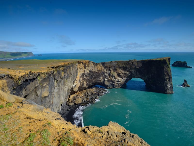
Dyrhólaey
Dyrhólaey is a nature reserve. The protected areas are necessary to ensure protection while ensuring public rights. Some areas are closed for part of the year to preserve wildlife, others are closed all year round due to sensitive natural monuments, traffic is also limited in some areas to people, and others are open all year round.
More information about DyrhólaeyDyrhólaey is a 120-meter high promontory not far from Vík. The place got its name from the massive arch that the sea has eroded from the headland. When the sea is calm, big boats can sail through it. A maniacal daredevil pilot has even flown through the arch with a small-craft airplane!
From the top of Dyrhólaey, there is a great view. The headland is thought to have been made in an underwater volcanic eruption late in the glacial period, not unlike the eruption of Surtsey. Several outcrops are in the sea; the highest one, called Háidrangur ("High column"), is 56 m. high. Dyrhólaey has been a natural reserve since 1978.
The promontory is widely known among sailors as "Portland" and English trawler fishermen beach where one can climb (at your own risk). According to legend, the Reynisdrangar needles were formed when two trolls tried dragging a three-masted ship to land. When daylight broke, they turned to stone. The Needles can be seen clearly from the village of Vík and are 66 meters above sea level at their highest.
In one of the many caves here – there is a local legend about a monster having lived here for many centuries. The monster seems to have disappeared after a landslide over 100 years ago…used to call it a "Blow hole." There are also unique rock formations all along the Birdlife here is abundant, with puffins and eider ducks being the most common species in the area. On top of the cliff, the lighthouse stands impressive and stoic in this often very windy area. Be careful not to go too close to the ledge of this dramatic cliff.
View
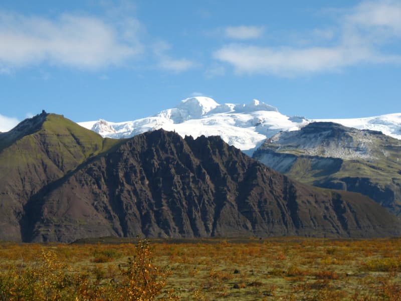
Kerlingarfjöll Mountains
The mountain massif Kerlingarfjöll (The Giantess Mountains; 800 - 1500 m) is the main ornament in the chain of mountains and glaciers framing the Kjölur area. It covers about 150 km² area southeast of The Temple Glacier (Hofsjökull) It derives its name from a single, 25 m high and dark hyaloclastite pillar protruding from the light-colored, rhyolite scree of the peak Kerlingartindur. The aforementioned types of rock represent the main structure of the mountain massif and this yellowish tint is the dominant color in the area.The area is full of small steaming hot springs, mud pools, and water fountains. It is truly a hiker's paradise. It is one of the largest geothermal areas in all of Europe and there are future plans to construct a large geothermal steam plant here for electricity to harness the massive amounts of energy stored here. The area is very unique, sensitive, and beautiful - why such a decision may be controversial if proper conservational steps are not taken when doing so.It is recommended to use 4wd vehicles because of the various and changing condition of the tracks and unbridged rivers, which have to be forded with the greatest of care. It is also recommended that people read the special brochure on driving in the interior before heading up there and remember, that off-road driving is strictly forbidden. Many of those who have visited the interior catch the bug and the only remedy is to come back again and again. It is like an incurable disease. Traveling across the interior was common during the Saga period, but after that up to the middle of the 18th century, superstition kept people away. Nowadays - more and more people enjoy this part of the country the whole year-round.
The small glacier patches up there have been retreating fast and now the summer skiing school, which was operated for decades, exists no more. Its complex of houses is now being used to accommodate travelers in the area during the summer months.
View
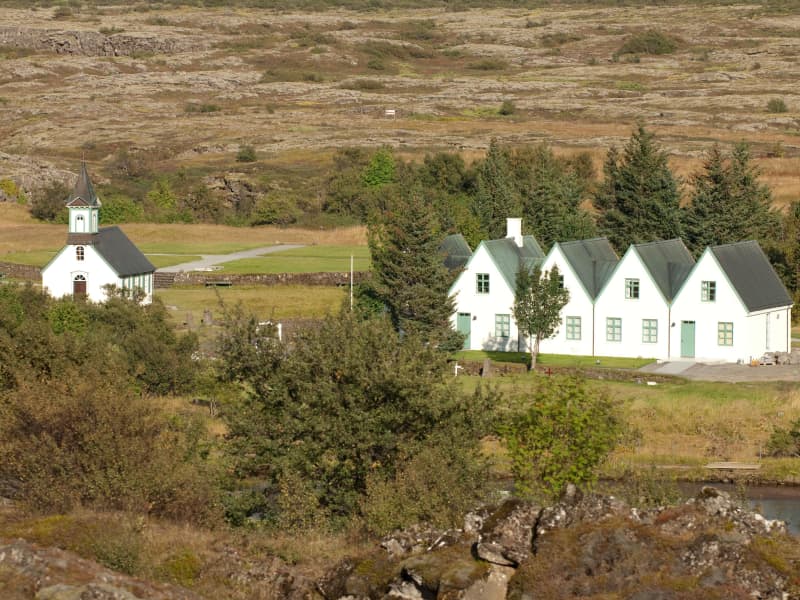
Þingvellir National Park
Þingvellir (Icelandic "Þing": parliament, "vellir": plains) is a place in the southwest of Iceland near the peninsula of Reykjanes and the Hengill volcanic area.It is famous for two reasons:As one of the most important places in Icelandic history. In the year 930 the Alþingi, one of the oldest parliamentary institutions of the world, was founded. The Alþingi met yearly, where the Lawspeaker recited the law to all of the gathered people and decided disputes as well. In the year 999 or 1000, the Lawspeaker Þorgeir Ljósvetningagoði made Christianity the official religion of Iceland. After the conversion, it is said that, upon returning from the Alþingi, Þorgeir then threw his statues of the old Norse gods into the waterfall that is now named Goðafoss ("Waterfall of the Gods"). At this historical place, the independence of the Republic of Iceland was proclaimed on June 17, 1944.As a national park (since 1928) because of the special tectonic and volcanic environment. The continental drift can be clearly seen in the cracks or faults which are traversing the region, the biggest one, Almannagjá, being a veritable canyon. This causes also the often measurable earthquakes in the area.
Þingvellir is situated on the northern shore of Þingvallavatn, the biggest lake of Iceland. The river Öxará traverses the national park and is forming a waterfall at the Almannagjá, called Öxaráfoss Together with the waterfall Gullfoss and the Geysir of Haukadalur, Þingvellir is part of the most famous sights of Iceland, the Golden Circle.Þingvellir is a designated UNESCO World Heritage SiteThingvellir, 50 km (31 miles) to the east of Reykjavík, is the national shrine of Iceland. Iceland's most historic site, and one of its most beautiful places, is also part of The Golden Circle tour. The oldest existing parliament in the world first met here in AD930. The Alþing met here every year to enact laws, including the law passed in AD1000 to introduce Christianity into the island. It has always been the focal point for the country, and whenever a major event is to be celebrated, thousands of people come here. At the celebration of the 1,100th anniversary of the first settlement in 1974, more than 60,000 people packed into Thingvellir.Nearby Lögberg is the cliff overlooking the place where the Alþing (assembly) met, and speakers stood to address the gatherings from this point. Nearby is Drekkingarhylur (The Drowning Pool), where mothers of illegitimate children were drowned. It is sited in the river Öxará in Almannagjá, a lava gorge, which with the Öxarárfoss waterfall, is an impressive sight.Peningagjá (The Money Chasm) is a deep fissure filled with crystal clear spring water; people throw coins into it from the bridge that lies across. The coins give off strange reflections as they drop through the water, it is said that if you can follow the coin all the way down until it comes to rest on the bottom, your wish will come true. Scubadiving and snorkeling in wet suits are becoming increasingly popular here.There is an old church at Thingvellir. Beside the church is the national burial ground.Thingvallavatn is the largest lake in Iceland, 83sq km (32sq miles) and over 100m (328ft) deep. The only outflow from lake Thingvallavatn is the river Sog, a famous salmon river with beautiful blue water. The lake's catchment area is 90% underground and the water from the thousands of cold springs has a constant temperature of 3-4°C the whole year-round.The anglers, who use boats for their fishing, have to be careful and watch out for changes in the weather. The lake becomes a boiling pot when the wind starts blowing. The catch in the lake has always been a necessary part of the survival of the farming families on the lake. They have netted the lake traditionally for centuries. Angling permits are sold in the little shop and visitors center in the camping area or at Hotel Valhöll. The catch consists of brown trout and lake char.It is said that these fish became isolated in the lake in the wake of the last ice age when the terrain rose at the south end of Þingvallavatn. These two species are a living testimony to how the evolution of species occurs in nature, as over a period of 10,000 years they have adapted themselves to various habitats in the lake. The constant, regular influx of groundwater into Lake Þingvallavatn, together with a very varied habitat, has created good conditions for fish and other life forms in the lake, to which they have adapted even more. This has resulted in the fact that both the brown trout and char in Thingvallavatn are amongst the largest to be found in the world. The trout are said to be as big as over 20 kg (max weight) and the char over 10 kg (max weight), which is at the max of both species size ranges.The lake is part of the Þingvellir National Park. The volcanic origin of the islands in the lake is clearly visible. The fissures around it - the famous Almannagjá is the biggest of them - indicate that here the tectonic plates of Europe and The Americas are in a conflict. In this lake, with the large quantity of sulfur and salt, the lake is extremely light and the water seems to be in less weight than other lakes.
View
Geysir Geothermal area
One of the greatest natural attractions of Iceland and part of the famous "Golden Circle Tour," The Great Geysir, or Stori-Geysir, has been dormant since 1916 when it suddenly ceased to spout. It came to life only once in 1935 and quickly went back to sleep. Since then, its repose has sporadically been disturbed by the dumping of tons of carbolic soap powder into its seething orifice to tickle it to spout.
It is not exactly known when Geysir was created. It is believed that it came into existence around the end of the 13th century when a series of strong earthquakes, accompanied by a devastating eruption of Mt. Hekla, hit Haukadalur. In this geothermal valley, Geysir is located. What is known is that it regularly spouted every third hour or so up to the beginning of the 19th century and, after that, progressively at much longer intervals until it completely stopped in 1916. Whether its silence is eternal or temporary, no one knows.
When it was alive and shooting, it could thunderously blast a spectacular jet of superheated water and steam into the air as high as 60 to 80 meters, according to different sources. Its opening is 18 meters wide and its chamber 20 meters deep. One reason for cessation is believed to be the accumulated rocks and foreign objects thrown into it by thousands of tourists throughout the years. Though definitely damaging, this could not be the only reason for its dormancy.
The Great Geysir was among the most notable geysers in the world, such as those in Yellowstone Park, New Zealand, and North Iceland. The English word "geyser" is derived from the Icelandic word "geysir," which means gusher. Though the Great Geysir itself is now more or less inactive, the area surrounding it is geothermically very active with many smaller hot springs.
The attraction of the area is now Strokkur (The Churn), another geyser 100 meters south of the Great Geysir, which erupts at regular intervals every 10 minutes or so, and its white column of boiling water can reach as high as 30 meters. The whole area is a geothermal park sitting on top of a vast boiling cauldron. Belching sulfurous mud pots of unusual colors, hissing steam vents, hot and cold springs, warm streams, and primitive plants can all be found here.
A short distance away to the west stands the small Laugarfjall Mountain with a panoramic view overlooking the Geysir area. King Christian IX of Denmark visited the area in 1874 and by the foot of the mountain are the rocks where he leaned while his hosts tried to impress and amuse him by boiling eggs in the hot springs. The rocks are now called Konungssteinar ("The King's Stones").
View
The Flói Bird Reserve
Northwest to the town of Eyrarbakki is a wetland area, rich in birdlife. The reserve has walking paths and a bird hide, an ideal spot for bird watching. The Flói Bird Reserve is listed in the Bird Life international Association. The Reserve is characterized by its flood meadows and numerous small ponds. Approximately 70 species of birds have been recorded in the Reserve. During spring and autumn migration Greylag Geese and White-fronted Geese can be found as well as Wigeon and Tufted Duck and various waders such as Snipe and passerines like Wheatear. During winter, birds, chiefly gulls and sometimes Long-tailed Duck and Common Eider, are concentrated in the estuary of the river Ölfusá. Whooper Swan, Teal, Mallard and Goosander are attracted to open water in winter.
View
Lónsöræfi
In Lón District, the most eastern area of the Vatnajökull Region, lie the Stafafellsfjöll mountains, also called Lónsöræfi. They dominate the skyline east of the Vatnajökull glacier and have long comprised one of Iceland’s most extensive protected areas. Besides the deep, rugged canyons, the landscape displays a wide range of colors owing to the presence of rhyolite and other colorful rocks. In contrast, there are also lushly vegetated and sheltered valleys offering a very good chance of spotting reindeer. The numerous hiking trails make this area perfect for hiking. Keep in mind that getting there can be very difficult and one should seek advice from a visitor- or information center before attempting to go there.
View
Ósland
Ósland is an island accessible by a manmade isthmus (land bridge) and is situated just a few steps from the harbor area. Ósland was once an island but is now connected to the mainland. It is a conservation area popular for hiking.
There is rich birdlife, and the Arctic Tern is predominant during the nesting season. Ósland is situated just a few steps from the harbor area in Höfn. Walking trails circle the pond, Óslandstjörn, and are along the shore. On the hill, Óslandshæð is a memorial to the fishermen and an information board about the surrounding natural area.
From Ósland, you can follow the nature trail set up to model the solar system – it's been scaled down and has its sizes and distances in proportion. There are also visible impressions of trees in the basalt rock in the area, trees that have been covered by lava a long time ago.
View
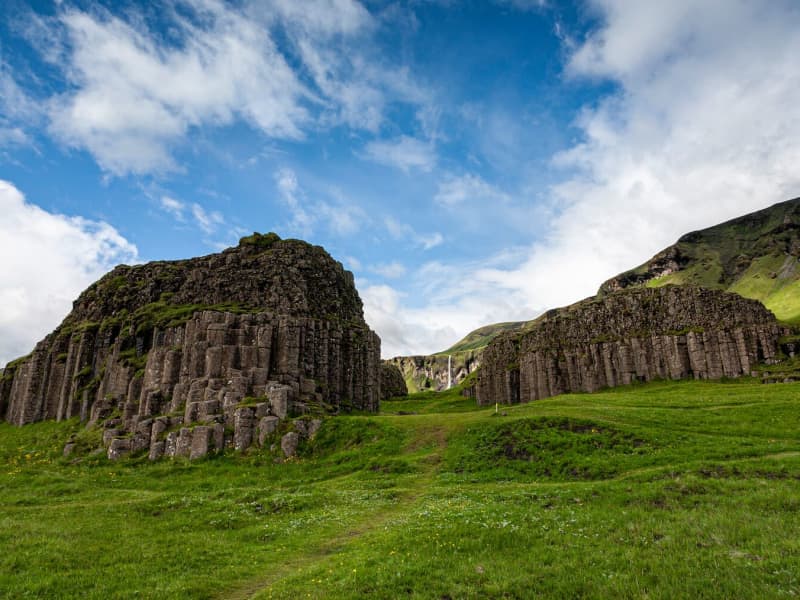
Dverghamrar
Dverghamrar (Dwarf Rocks), just east of Foss, is a peculiar and beautiful columnar basalt formation. On top of the columns, there is cube-jointed basalt.
The landscape is thought to have been molded at the end of the Ice Age. The sea level was higher at that time, and it is believed that the waves caused the peculiar look of the rocks. Dverghamrar is a protected natural monument.
Columnar basalt is formed when lava flow gets cooled, and contraction forces build up. Cracks then form horizontally, and the extensive fracture network that develops results in the six-sided formation of the columns.
View